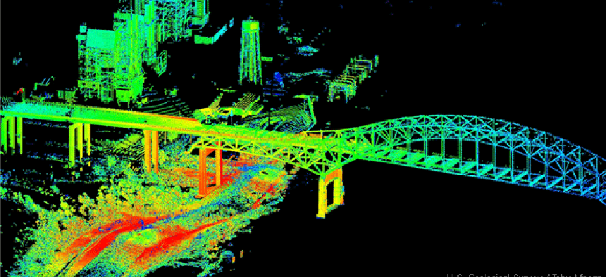
How LIDAR is revolutionizing maps, geospatial data


Connecting state and local government leaders
With improved technology and lower costs, LIDAR has brought fine-grained, 3D capability to "just about everybody who uses a map."
First of four parts.
It's faster than a speeding bullet. It can measure buildings in a single pulse. It can scan the ocean floor and peer through forest canopies to measure undergrowth. It's LIDAR – light detection and ranging.
A standard LIDAR system emits a beam of light from a laser source and then captures the returned light in sensors as it bounces back from a reflecting object, measuring the distance by calculating the time required for the round trip. While LIDAR systems were used by the federal government as early as the 1960s — primarily for atmospheric studies — it wasn't until after 2000 that a combination of factors resulted in a boom of LIDAR data-gathering projects that are now bearing fruit at federal, state and local government levels.
U.S. troops have used LIDAR to map the difficult terrain in Afghanistan and a Colorado State University scientist used it in creating the first forest height map to measure carbon cycles in ecosystems.
"It's being used by just about everybody who uses a map," said John English, LIDAR data coordinator for Oregon's Department of Geology. "Every municipality and county is using it. The Department of Land Management and the U.S. Forest Service use it for their forest inventory surveys."
According to English, the agencies are increasingly turning to LIDAR because the technology has gotten both less expensive and more accurate, and, because surveys are generally done from aircraft, vast amounts of territory can be covered quickly. "It's been a huge timesaver," he said. "The estimate of savings is incalculable."
Kirk Waters, a program manager at the National Oceanic and Atmospheric Administration's Coastal Services Center, agrees. "LIDAR is a way to get fairly accurate elevations over a broad area at a reasonable price," he said.
Waters pointed to a March 2012 report by the U.S. Geological Survey that found that a national program of collecting LIDAR data would result in net benefits of between $116 million and $620 million a year. According to the study — the National Enhanced Elevation Assessment — the biggest savings are to be realized in flood risk management, infrastructure and construction management, natural resources conservation, agriculture and water supply management.
Elevation data can tell city planners where to plan mitigation for floods. It can tell farmers where to expect irrigation runoff and where to plant crops that require the most expensive fertilizers. Cities are using LIDAR to build 3D maps.
In all, "the study came up with 600 different uses,” Waters said. “There's just tons of applications."
"It's at the beginning stages," said Steve Snow, a mapping and LIDAR specialist with geospatial tech company Esri. "Everybody is learning about the technology." Esri, in fact, just added the ability to import native LIDAR directly into its industry-standard ArcGIS software.
In principle, the technology behind LIDAR is simple. By measuring the time it takes light to bounce off an object, and knowing the speed of light (186,000 miles per second), one can detect the distance of the object. The challenge has been in developing equipment that can fire rapid pulses of light — in some cases up to 150,000 pulses per second — and that can measure the returning light with accuracy.
LIDAR systems vary in the wavelengths of light and the power of the pulses employed. High-energy pulse systems, for example, typically are used for atmospheric research, while lower-powered micropulse systems are more often employed for downward scanning, since they are considered "eye safe."
And although most airborne LIDAR systems use 1064-nanometer laser beams, bathymetric LIDAR systems — those used to penetrate water — employ a narrower 532-nm beam. Bathymetric LIDAR also transmits two light waves, one infrared and the other green. As a result, it can detect two returning signals, one off the water surface and the other from the seabed.
Other critical elements in the development of LIDAR systems have been the enhancements in the production of higher-resolution and more flexible scanners, optics and photoreceptors.
Finally, collecting LIDAR data from aircraft involves a few additional challenges. Because the LIDAR sensor is moving, the changes in location between the firing of the pulse of light and its return must be accounted for in making any measurement. That required the development of fast, high-resolution GPS devices and inertial measurement units that measure velocity and orientation.
Coordinating of this, of course, is no mean feat, nor is digesting the massive amounts of data that are produced.
According to Waters, NOAA's LIDAR scans are shooting between 100,000 and 200,000 points per second with about up to 10cm of error. "The rest is math," Waters said. "Lots of math, but it's still just math."
NEXT: LIDAR proves its worth in the floodplains of the Red River Basin and the Forests of Oregon


