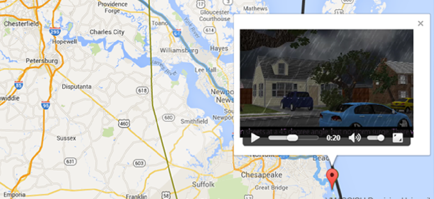
Hurricane simulation tool encourages citizen evacuation


Connecting state and local government leaders
Researchers at Old Dominion University's Virginia Modeling, Analysis and Simulation Center have developed a tool that graphically demonstrates the threat posed by high winds and rising water during a storm.
Just in time for hurricane season, Old Dominion University's Virginia Modeling, Analysis and Simulation Center (VMASC) has developed a tool designed to graphically demonstrate to residents of southeastern Virginia the threat posed by high winds and rising water during a storm.
Residents who do not evacuate not only put themselves in danger, but they cost municipalities money and risk the lives of first responders who must try to rescue them.
According to the World Resources Institute, southeast Virginia has been experiencing some of the highest rates of sea-level rise along the entire U.S. East Coast. Rising sea levels exacerbate flooding, making hurricanes even more dangerous to residents in to low-lying areas.
The Hurricane Evacuation Encouragement Demonstrator (HEED) prototype was developed by VMASC for the Virginia Department of Emergency Management as a way to convince residents to evacuate during major storms. From the beginning, the work focused on providing an audio-visual “hurricane experience” as clearly and fully as possible on the small screen of a personal computer to encourage citizens to evacuate when called upon to do so by the state.
The tool also helps those evacuating select a route, get instructions and maps and find shelters and fuel stops. The concept was broadened to include a mobile application to assist evacuees once they are actually on the road.
Users put their starting address, chosen evacuation route, and the strength of the storm into the site. HEED has been made dynamic so that real time tracks of storms headed for Virginia’s Hampton Roads area can be put into the program, said Sol Sherfey, senior project scientist at ODU-VMASC and principal investigator for the HEED project.
After users hit enter, they will receive two important pieces of information: their chosen evacuation route, with any expected detours because of wind and high water, and a short, animated video of the view from their front window if they decide to stay.
"It's designed to simulate what individuals will actually experience if they decide to stay in their homes in the face of a big storm," Sherfey said.
Sherfey said VMASC researchers will maintain the HEED site through this hurricane season, then turn it over to the Virginia Department of Emergency Management, along with the Web-based databases of fuel stops, shelters and storm surge data. They have also developed administrative tools to enable state personnel to maintain the databases and the site without specialized programming skills.
Old Dominion University's Virginia Modeling, Analysis and Simulation Center was founded in 1997 as an academic partner of the Department of Defense's Joint Forces Command. Located in Norfolk, Va., the university was host to a recent forum on the effects of rising sea levels in the Hampton Roads area, home to one of the largest military installations in the world.
The area will also be the site of a two-year pilot program between Old Dominion University, the private sector and the government to research ways to combat the effects of sea-level rise.


