Spike turns smartphones into remote-measuring tools


Connecting state and local government leaders
ikeGPS Spike offers emergency-response managers a new mobile tool for making rapid in-the-field measurements that can easily be integrated into responders’ databases.
When a disaster strikes, simply measuring the amount of damage in order to prioritize resources can be a challenging and time-consuming undertaking. ikeGPS Spike offers emergency-response managers a new mobile tool for making rapid in-the-field measurements that can easily be integrated into responders’ databases.
The potential uses for Spike – which has been developed with funding from In-Q-Tel, the non-profit, strategic investment firm that identifies innovative technology solutions to support the missions of the U.S. intelligence community – has potential for a broad array of federal missions. Besides emergency-response planning and damage assessment, the tool can help planners with infrastructure asset management and transportation load planning
"The ability to measure a structure or between two different points applies to so many different federal job functions," said Jeff Ross, ikeGPS' chief marketing officer. "For example, the ability to measure a building applies to military/special ops doing intelligence gathering or a government facility manager preparing a building maintenance work order. They are both using the same Spike photo measure capabilities, but in very different ways."
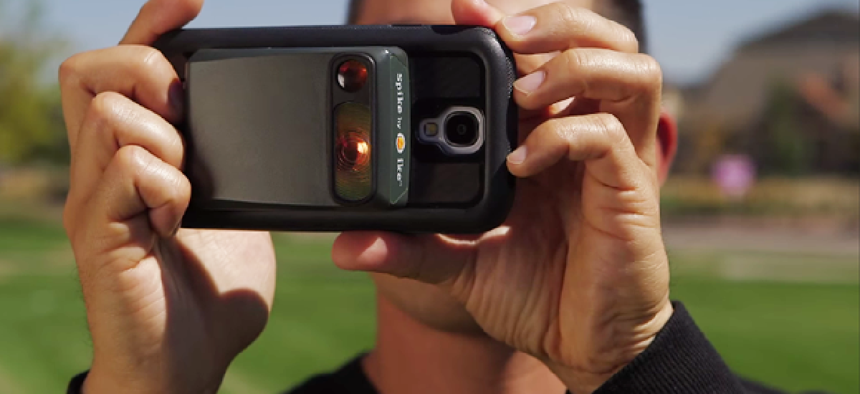
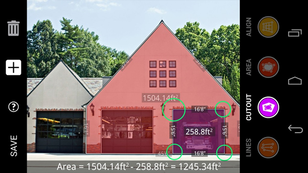
Spike's built-in laser rangefinder works with the camera in a smartphone or tablet to record and analyze the dimensions of any scene. By taking the real-time laser measurements and integrating them with the photos and data from the GPS in the phone or tablet, Spike can record the dimensions and geospatial location (latitude, longitude and altitude) of any object.
In fact, by analyzing those three types of data, Spike is even able to calculate the relative differences in location, including elevation, of multiple objects. An analyst could, for example, determine that the base of a water tower 500 feet away is 5 feet higher than the parking lot from which the photograph was taken.
The measurement and location data are saved with the photos and can be shared with others via email or a cloud-sharing service as a PDF file, a Spike (XML) file or a KMZ file.
Thanks to location data stored along with the images, analysts can open existing files to make new measurements of captured objects.

The Spike hardware is a 2-ounce unit measuring 3.3"x2.35"x0.82" that attaches to the back of a cell phone case or a tablet. Communication between the two devices takes place over Bluetooth Smart, and analysis of the gathered data is performed by a Spike app that is downloaded to the smartphone or tablet.
Spike can, of course, be used for a wide variety of applications in addition to damage assessment, such as measuring the area that needs to be painted on a structure, estimating the square footage of a tract or mapping vegetation.
What's more, because Spike's laser rangefinder works up to 650 feet away, many measurements can be taken at a safe distance from potential hazards.
"It could save a home inspector from having to be up on a 10-foot ladder or up on a roof," said David Foster, an engineering consultant with Cherokee Nation Technology Solutions.
The laser – with a margin of error of plus or minus 2 percent – isn't accurate enough to replace hands-on measurement entirely. It lacks the precision, for example, to provide a repair crew with measurements to cut wood for replacement studs on the side of a damaged structure. "The way to think about Spike is that it is an awesome estimator," said Brian Soliday, ikeGPS vice president of sales. "But it's not going to be to the quarter inch."
Soliday also noted that that the accuracy of calculations of measurements varies somewhat depending on the degree of angles between objects in a photograph. Accordingly, where more accuracy is required it's a good idea to take photos from several angles.
"Spike provides integration of multiple tools, so you don't have to carry around a bunch of devices," said Foster, who has experience as a former Army engineer doing damage assessment.
He added that in addition to simplifying and speeding rapid field assessment, Spike offers potential for integration with agency applications. He imagines plugging the results of a Spike analysis directly into an organization's workflow. "Field staff could make assessments and have signoff then and there instead of having to drive the report back to a district headquarters to get stamped and improved," he said. "It's almost instantaneous."
That type of integration, however, will have to wait. ikeGPS does not yet have an API or software development kit for Spike, though the firm plans to deliver them soon.
Spike currently works with Android and iPhone devices. It is powered by a lithium-ion battery that is recharged via a USB port.
Spike is available through Carahsoft -- a large IT solutions provider for federal, state and local government – and has a list price of $499.


