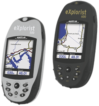
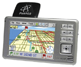
It could wind up being the next check-box, must-have feature for mobile computing devices. It's already in cars and many cell phones. Itronix Corp., maker of rugged notebooks, told GCN that up to 40 percent of the people buying its latest GoBook III opted for it as a $375 add-on. It's Global Positioning System technology, and it's gradually becoming more mainstream than ever.For those of you who've only heard about it in passing, GPS is a satellite-based navigation system consisting of 24 satellites put into orbit by the Defense Department. GPS receivers on the ground take information transmitted from these satellites and use triangulation to calculate a user's exact location.Once the user's position has been determined, the GPS unit can calculate other information, such as speed, bearing, track, trip distance, distance to destination, sunrise and sunset, and more.The GCN Lab wanted to know how well the technology works today. So we rounded up four GPS devices and tackled the Washington area and beyond.GPS devices come in all shapes and sizes. What's good for one user may not be good for another. At this point in the technology's development, GPS doesn't appear to be well-integrated with other platforms. For example, the Pharos EZ Road Pocket GPS Navigator is also a personal digital assistant and MP3 player, but it can't be all three at once because of memory and design limitations. By contrast, the DeLorme Earthmate GPS LT-20, our Reviewer's Choice, is a notebook add-on, which may not appeal to mobile users who want handheld convenience and long battery life from a GPS tracker.Still, we liked the Earthmate solution best precisely because of its connection to a notebook platform. Using bundled DeLorme software, we turned our notebook into a powerful mapping tool with the entire United States at our fingertips. The handheld devices we tested would require costly memory upgrades to put that much mapping power in your pocket.For getting acquainted with GPS and how it will change the way you compute on the road, the Earthmate is a worthwhile solution. Low price, full U.S. map coverage, powerful and versatile software, voice recognition Can only be used with a computer A- A- A- B+ A-DeLorme's $100 Earthmate LT-20 is a GPS device designed to be used with a notebook computer. It consists of a small, 2- by 2.5- by 0.5-inch GPS antenna that connects via a USB port, and comes bundled with navigation software and street maps of the entire United States. In other words, it has just about everything'at a price that's hard to beat.The Earthmate LT-20 was our favorite GPS device, but it's definitely a product that will appeal differently to different users. That's because both its strengths and weaknesses center on its integration with a computer. Unlike the other GPS devices we reviewed, the Earthmate LT-20 is just an antenna, and your notebook'assuming you have one'is the actual computing device. Depending on how you use GPS, this could be a good thing (a notebook is powerful and can run sophisticated mapping software) or a bad thing (you may not want to lug your notebook through the woods or put it on your passenger seat while you drive).In itself, though, the Earthmate LT-20 is a good product. It normally took 40 seconds or less to acquire a signal, which is relatively fast (less than 20 seconds if we were already running the program). The directions the device provided were accurate and reliable. Like all GPS devices, the Earthmate made its share of mistakes, but nothing too glaring.We especially liked the voice recognition feature that allows users to ask the computer questions, such as 'When is the next turn?' Of course, you need a microphone for your notebook.Best of all, the system is very versatile. Because it's PC-based, almost every feature is customizable. And the software is extremely powerful. Planning routes, searching through maps and finding locations were a snap. It also helped that the bundled map software is equally robust. We found DeLorme's Street Atlas 2005 incredibly up-to-date on the latest street maps. It has more than four million points of interest to help you navigate, from gas stations to golf courses.If there was one thing we didn't like, it was more of a cosmetic distraction. The system's voice for giving directions is a tinny computer voice, straight out of the 1983 movie 'War Games.' You can choose other voices, but they're all annoying computer voices. Most other commercial units have much nicer, human voices.Not sold on an Earthmate LT-20? It's understandable. To get the most out of this device, you need to understand how you plan to use it. For example, you can't go mobile with it for long stretches unless you have a notebook with exceptional battery life. Yes, you could get a car adapter and power your notebook from a lighter, but setting up the system every time you get into a car might be a hassle. We considered permanently installing an old notebook into a car, sort of how police cars include notebooks, but that seemed like going overboard, and an invitation for someone to steal the car.Ultimately, the Earthmate LT-20 is an inexpensive way to add GPS to a notebook for occasional use. If you were setting up a mobile command post, it would certainly come in handy. But if you're driving around looking for a location, it's not exactly ideal.DeLorme Inc., Yarmouth, Maine, 207-846-7025, Compact, lightweight, rugged, user-friendly Limited usefulness for the average user, detailed maps not includedeXplorist 500 B B B+ B C+eXplorist 600 B- B B- B C+The Magellan eXplorist line represents a different kind of GPS device. It's not primarily meant to get you to the nearest coffee shop; but border guards, Forest Service workers and other outdoorsy people can use an eXplorist GPS device to pinpoint their location and receive general directions in wide-open spaces. We used the 500 and 600 models during a three-week cross-country trip.Neither eXplorist is a typical car navigation system. They do not come with de- tailed street maps, although you can add them provided you upgrade the standard 16M of memory via the devices' Secure Digital slots. They only have highway-level maps preinstalled. Even with street maps installed, the eXplorists weren't built to give you directions from where you are to where you're going.However as a hiker's aid, for example, the two devices are quite good. Compact, rugged and waterproof, the GPS receiver weighs less than six ounces and measures 2.2 by 4.7 by 1.3 inches.The $400 eXplorist 500 has a 16-color display, 8M worth of built-in maps and 8M of spare memory. The eXplorist 500 is also the first GPS receiver to be able to calculate an area and its perimeter. It also provides vertical profiles for navigating trails.The $450 eXplorist 600 has everything the 500 model has but also comes with a three-axis electronic compass, a barometric-pressure altimeter, barometer and thermometer.For GPS enthusiasts, both models also feature the Magellan geocaching manager software. Geocaching is a fast-growing adventure game for GPS users. The basic idea is for individuals and organizations to set up hiding spots, or caches, all over the world and share their locations on the Internet. GPS users can then work with the location coordinates to find the caches.The Magellan software simplifies geocaching by loading data directly from the Internet to the eXplorist.We liked both devices' interfaces. The controls and navigation screens were well-thought-out and intuitive. The color screens were bright and easy to see in all lighting conditions. Overall, we had no trouble figuring out where we were and where we were going.Sometimes, though, getting situated took a bit longer than expected. Despite the products' TrueFix GPS technology, which is touted to use 14 parallel channels and additional satellite-based augmentation systems for fast signal acquisition and accuracy to within three meters, we found location acquisition slow. It could take up to 45 seconds from startup for the eXplorist 600 to figure out where we were.Without standard street maps'a $150 option'or topographical maps, the eX- plorists are of limited use to the average person. Still, during our time in the backwoods, we could count on both eXplorists to get us to the right location.Thales Navigation Inc., Santa Clara, Calif., 408-615-5100, Easy to set up and install, plays media files, includes maps of entire United States Too small, difficult to see and hear, imprecise directions C+ C+ A- C+ B-The $550 EZ Road is Pharos' only all-in-one GPS navigation device. It's a thin, light device that can fit in your pocket and help you navigate streets and highways anywhere in the United States.[IMGCAP(2)]Setting up the EZ Road was easy. First, charge the battery (which lasts about five hours). Next, install the synchronization software on a Windows computer. Finally, upload maps to the device.Get used to that last part, because you may have to do it a lot. Because the device comes standard with just 32M of memory and a 128M add-in card, it can only hold a few maps at a time. We loaded maps for the Washington metro area, which included all of Maryland, D.C. and Northern Virginia, and had a little room to spare. If you want to spring for extra memory, the device supports Secure Digital memory up to 512M.We tested the EZ Road on a trip to the Chesapeake Bay. The GPS locator proved accurate and reliable, and the time it took to acquire a signal and triangulate our position was relatively short, usually under 30 seconds.But the directions the EZ Road gave us were a different story. For example, the EZ Road tells you when to turn by verbally alerting you that a turn is approaching and emitting a chime when you should actually turn. The problem was that the lag between alerts was too long and didn't account for the road we were on. The device would tell us a turn was coming, but it could have been three roads ahead. On a busy, high-speed road, we could end up blocking traffic for three blocks. Then the chime to turn came when we were practically on top of the turn'highly dangerous. A little more detail, such as how many miles to a turn, would have been helpful.Accuracy of directions was also a problem. At one point the EZ Road device told us to merge onto a highway after we'd already done so. Another time it told us to turn onto a road that did not exist. And it totally missed the location of a friend's house.Finally, we had a hard time simply using the device after it was up and running. The touch-screen keyboard was too small, and because addresses must be typed manually, it led to several mistakes. We'd end up bent over the device, squinting at the tiny, dim screen, and re-typing. What's more, the verbal commands and cues, even on high volume, were not very loud.On a different note, the EZ Road can also act as a Windows CE-based PDA and MP3 player, but with so little standard memory, such functionality is almost impractical. Even with a few maps and several MP3 files, the device won't let you listen to tunes and navigate at the same time. We also had significant trouble moving Outlook information to the EZ Road, eventually resorting to manual data entry.Despite the EZ Road's compact design and easy setup, it didn't work as well as we'd hoped.Ultimately, we'd rather get out directions from Mapquest and our MP3 player from Apple.Pharos Science and Applications Inc., Torrance, Calif., 310-212-7088,
MAGELLAN 500, 600: Without built-in street maps, these devices are of little use to motorists. They're great in the backcountry, though, and especially suitable for enthusiasts of geocaching.
PHAROS EZ Road Pocket GPS Navigator: It's compact and easy to set up'just don't count on it for accurate driving directions.


