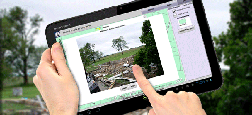
App provides disaster assessment on the fly with ArcGIS Online


Connecting state and local government leaders
A Michigan county is using WebMapSolutions to build a mobile app that provides faster, more complete damage assessments.
It doesn't even have a name yet, but Jeff Boudrie, a GIS specialist with the planning department of Monroe County, Michigan, is convinced that the application he is developing will not only save money and staff time, but it will allow the state to respond more promptly to disasters.
To date, the department has relied on paper damage assessment reports. But a recent incident convinced Boudrie a change was needed.
"Back in June 2010 we had a couple of tornadoes that ripped through the county," he said. "The county damage assessment team, which at the time consisted of two people, was called out at 5 o'clock Sunday morning. We split the township up geographically. I took one side west of the highway, and the other gentleman took east of the highway."
The team soon learned that the Red Cross also had sent people out to do damage assessment. "So we took their paperwork and kind of twisted [it] together with our paperwork and compared notes," Boudrie said. But there were two problems. First, he said, we began to realize that they used a process similar to ours, but they were doing it just a little differently. “Their level of damage was different than ours." Second, the state was waiting for the assessment to determine whether the governor would declare a state of disaster.
When he realized they needed a faster way for fewer employees to quickly process damage reports, Boudrie began to look for a mobile application.
He found help from WebMapSolutions, a GIS software development company that had already worked with Esri to develop a mobile data-collection application based on ArcGIS Online. With WebMapSolutions, Boudrie built an application with the working title "Monroe Mobile" that is being tested on Android tablets.
In the application, we physically put a point on the map -- or we can click on a parcel -- and a form pops down where we fill in the level of damage, Boudrie said. "There is also a field for us to give comments about the type of damage. Was the structure completely moved from the foundation? Was the roof blown off?"
Not only does the application simplify data collection, it makes it possible to get the data where it needs to go more quickly. "Back at the emergency operation center there can be a dashboard map projected up on the wall, and as we collect data, if we go to a Wi-Fi hotspot or if we happen to have a phone that has that capability, we can upload our changes," said Boudrie. "It's almost instant gratification."
And the mobile application would also make it easier for shifts of responders to coordinate operations. “If I was out collecting data for 12 hours and I need to go home and get some rest, when the next shift the comes in, I could just hand off my tablet to them, and they would already know by looking at the map where I've been," he said. "They can pick up where I left off."
The team is still working out a few bugs, but Boudrie said he's eager to pitch the application to the director of emergency management for final adoption. "I want it really, really bad," he said. "It's going to make our job easier out in the field, and the sharing of information is going to be so much faster. We will be able to provide a report to the state much faster than we’ve been able to in the past."

NEXT STORY: West Virginia U. brings Super Wi-Fi to campus


