Storm surge map will alert coastal residents at risk


Connecting state and local government leaders
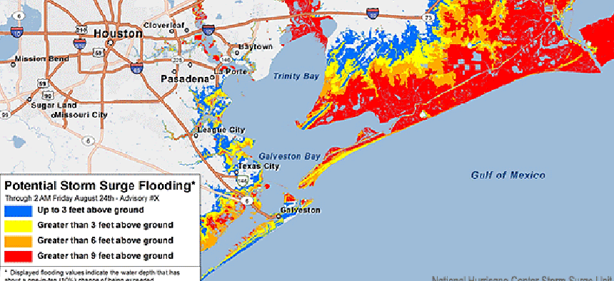
The National Hurricane Center's Potential Storm Surge Flood Map will be available online within 60 minutes of a hurricane warning, showing where flooding could occur and how deep the water could be.
As the 2014 hurricane season approaches, emergency-response managers and residents of vulnerable coastal regions will have the advantage of a new tool that will provide advance warning about the extent of expected storm surge flooding.
The National Hurricane Center's Potential Storm Surge Flood Map, which will be available at www.hurricanes.gov within 60 minutes of the issuance of a hurricane warning, will display just where flooding from the hurricane could occur and how deep the water could be in various locations.
"Whenever we have a landfall of a tropical system, it's no secret that the No. 1 threat, the No. 1 killer, is storm surge," said James Brinkley, operations manager of NHC's Storm Surge Unit. "And yet we haven't had a detailed graphic that we can provide to our users, our partners, the public, to help communicate that threat."
The new interactive map fills that gap. The map's projections are based not just on elevations in the affected areas but also on real-time analysis of the approaching storm.
"In the past, we would run a particular model called SLOSH -- the National Weather Service's storm surge model – based on one scenario from the National Hurricane Center advisory forecast," Brinkley said. "The one problem with that is that no forecast is 100 percent accurate. There is always a certain amount of error associated with it."
Accordingly, the NHC team decided to use a probabilistic approach. "We look for multiple tracks in a computer simulation," Brinkley said. "By the time we run thousands of scenarios, we start to get a probability of where we anticipate the highest storm surge. We've taken it one step further and now have overlaid it into a GIS format. We can determine down to a fairly high resolution where to expect a range of storm surge values."
In fact, by accessing the map – which has a resolution of 250 meters – residents and emergency-response planners can determine nearly down to the house level how deep the water is expected to be. The team didn't want higher resolution, Brinkley said, "because we don't want to allow the public to counter the emergency managers or undermine their decision authority. We still want the public to rely on their expertise. When they say it's time to go, we want them to follow that guidance."
Brinkley's team already has plans to improve the map. "This is just in its beginning stages," he said. Specifically, the team hopes to port the map to a Google interface so they can allow users to navigate and pan around instead of viewing a single graphic focused on one region.


