Fairfax County builds searchable crime-data mapping app


Connecting state and local government leaders
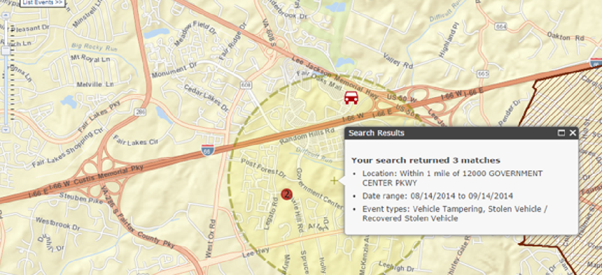
Fairfax County's mapping team has developed the Police Event search engine and mapping tool that makes crime data open and easy to use for both developers and end users.
Counties surrounding Washington, D.C., are stepping up their use of geospatial and visualization tools to make it easier for local police to determine not only what kinds of crime are being committed in their jurisdictions but to pinpoint where it is happening.
Last year, Prince George’s County, Md., rolled out a web-based application called StarLight that displays data about crimes that cross the Washington/Maryland border.
Following suit, Fairfax County, Va., went live this past spring with a system that integrates search engine technology with a new Police Events application that creates visualizations of search results in map form.
Work on the system began about six months ago, not long after officials at Fairfax County’s Department of Information Technology realized that the 500,000 data points that mark police events were overwhelming their existing application.
“It was fine when it launched eight years ago, but over time it got less and less usable. The performance of it decreased because the [police events] that underlie all this increased in number quite drastically,” said James Callahan, lead application developer of geographic information systems (GIS) for the county.
The data still resides in the county’s legacy Oracle enterprise GIS database. To build the new application, Callahan had to create programs that move the data around across different systems. An automated nightly process now takes new data – about 100 to 200 new calls per day – from the 911 call center’s computer-aided dispatch system and writes the data into Geography Markup Language (GML). As GML is a form of the Extensible Markup Language (XML), a search engine built by software firm MarkLogic can read the geographic data natively.
“Anything that you’re looking at in the application is one day old or older. It goes back to 2006,” Callahan said.
Users can access the new application via a desktop computer or mobile device and search by location, date range or any of 12 event types – including assault, drug or sex offense or stolen vehicles, for instance – using the new search engine.
The system has a unique indexing scheme that rips through the data points at incredible speed, Callahan said, and returns results in multiple formats. That supports Calahan’s goal of making the system available to developers anywhere so they have easy access to GIS data, such as addresses, parcels, schools and more of the application’s 30 map layers.
“Just on the search part alone, we were able to increase our performance by a 10 times factor,” he said. The old version searched the 800-layer Oracle relational database layer by layer, column by column, which took time.
Using the old system, someone who wanted to search GIS data had to have a lot of information in advance, such as the map layer where the data could be found or even which column within that layer. Now users can enter search terms, and the engine searches all the GIS data in the database, although users can restrict the searches to particular layers if they prefer, Callahan added.
The application he built – which cost about $46,000 – on top of the search engine uses software from Esri’s JavaScript programming interface.
The application is designed to create a map and make it easy to add data points to it. Simplicity of use was important to Callahan in developing the Police Events application, so he made sure tools were built-in that would let him easily make additions when he identified new mapping information to include.
Other counties that have instituted mapping technology to provide crime information include Manatee on Florida’s west coast. It uses CrimeMapping.com to display information by crime type, date, address and reporting agency. Similarly, Baltimore County uses CrimeReports.com to show on a map where certain crimes happened. An advanced search option lets users search 16 categories within specified date ranges, and users can set up alerts to receive information about various crimes daily, weekly or monthly.


