How satellites track ground moisture from space


Connecting state and local government leaders
The soil moisture data from NASA's SMAP mission will benefit farmers and ranchers as well as those who do flood modeling and drought monitoring.
According to climatologists, the increasing impact of climate change means some regions will be wetter than ever, and some will experience unprecedented droughts. Yet while it’s already too late to entirely avoid the consequences of such changes, farmers and water-supply managers will soon have an satellite-based tool to help address these mounting challenges.
NASA’s Soil Moisture Active Passive (SMAP) satellite mission, which is scheduled to launch Nov. 5, will measure the water content of the planet’s soil every two to three days.
SMAP uses two microwave instruments to measure the water content in the top two inches of soil, with a resolution of 9 kilometers. According to Dara Entekhabi, MIT professor of earth, atmospheric and planetary sciences and an SMAP team leader, soil reflects microwaves, and the wetter the soil the more it reflects.
Microwaves have other advantages over other wavelengths. “We don’t want clouds in the way and we don’t want to use sun as illumination,” said Entekhabi. “Microwave is perfectly suited for that. It goes right through clouds, and we can use microwaves day or night. And we found that if you go to lower and lower frequencies you can see through more and more vegetation and also penetrate more and more of the soil.”
In fact, SMAP will carry two types of microwave devices – one passive and one active. A passive radiometer on board the satellite will measure microwave radiation coming off the ground. At the same time, a microwave radar device will send pulses to the ground and measure returning echo.
Employing the two types of devices allows the team of scientists to get past the limitations of each.
“The advantage of passive microwave is sensitivity. The disadvantage is that you need a large reflector to be able to focus on the surface,” explained Entekhabi. “Right now we already have a 6-meter reflector, which is big.”
What’s more, passive microwave only offers 40 km resolution. “That’s OK,” said Entekhabi. “But we can do better. That’s why we have the radar. It has the advantage of very high resolution – about 3 km or so.”
The disadvantage of the radar is that since the pulses go through any canopy of vegetation twice it carries a little more noise. “So what we do is combine the two routes’ relative advantages -- the resolution of the radar and the sensitivity of the radiometer,” said Entekhabi. “We came up with an intermediate accuracy product, which meets our requirements.”
While SMAP’s microwave devices only measure moisture content in the top two inches of soil, scientists can infer more about water conditions deeper in the ground.
“If you have a time series of surface soil moisture, you can infer what’s going on below the surface, because surface soil is the gateway to below the surface,” said Entekhabi. “Evaporation and precipitation, which add and subtract to the root zone, are all happening through the surface. So knowledge of surface layers is like having a bouncer at the club counting the number of people who go in.”
According to Entekhabi, the data will be of sufficient accuracy for the biggest users of soil moisture data – agriculture clients and those who do flood modeling and drought monitoring. The Defense Department is also looking to SMAP to provide information on ground conditions for deploying vehicles in the field.
“I’m delighted with the resolution, because it is by far the best we’ve had,” Entekhabi said. “But I wish it was higher.” There are applications, such as precision agriculture, that SMAP data won’t help because of its limited resolution. Entekhabi said that the only way to improve resolution with current technologies is to deploy a much larger reflector than is feasible. “It definitely wouldn’t fit in a rocket,” he said.
The data from SMAP will be downloaded to three ground stations – one in Norway, one in Alaska and one in the Antarctic. From there, the data will be shipped to NASA’s Jet Propulsion Laboratory for processing, after which it will be uploaded to NASA data centers in HDF-5 standard format, where it can be accessed by the public.
The entire process takes only eight to 10 hours, and the data is updated on a daily basis. “This is unique to SMAP,” said Entekhabi. “We turn around the data almost immediately. People want the data now.”
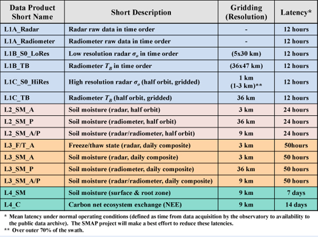
The SMAP baseline science data products are shown in the table below. These data products will be generated within the project's Science Data System and made available publicly through a NASA-designated data center. The products will conform to the HDF-5 standard.


