Mapsense aims to tame location data streams

The company is building tools to visualize and analyze streaming location data from smartphones and sensors.
Geospatial information systems offer powerful analytic tools for querying and displaying static location-sensitive data on maps. What they haven't been designed to handle is the massive streams of real-time location data that are now emanating from cell phones and the myriad sensors that make up the Internet of Things.
While some GIS vendors, including Esri, have moved to offer extensions to bring in streaming location data, the team at Mapsense has opted to design its product from the ground up to manage that deluge of location data.
"There is so much more location data in the world today," said Erez Cohen, cofounder and CEO of Mapsense. "One statistic I have heard is that there was more location data stored in 2014 than in all of previous history. When it comes to companies that are collecting very, very large streaming location datasets, traditional GIS tools sometimes flounder under the requirements of being able to visualize and analyze these datasets. That's the focus of our company."
Mapsense has just announced two products for immediate availability: Mapsense Enterprise and Mapsense Developer.
Mapsense Enterprise is a set of data analysis and visualization tools into which companies can port their streams of location data. Generally, the data is hosted in Mapsense's Amazon cloud storage, though on-premise storage can also be accommodated. In either case, access to the data and to Mapsense's tools is via a web browser.
Mapsense Developer is a set of open source tools that allow users to create data-driven, fully interactive maps with only a few lines of code. It’s based on D3.js, which has become the de facto library for web-based visualizations. Cartography and styling are simplified with the Mapsense CSS Machine, which lets users quickly create styles for Mapsense tiles, then grab the cascading style sheet and add it to their site’s master stylesheet.
"We definitely don't have all the functionality of [Esri’s] ArcView," said Cohen. "What we pride ourselves on is the data scale that we support and the fact that we can stream datasets. It's hard to present and visualize very large location datasets in ArcView. And try putting 100,000 data points even on a Google map -- you'll start running into browser issues."
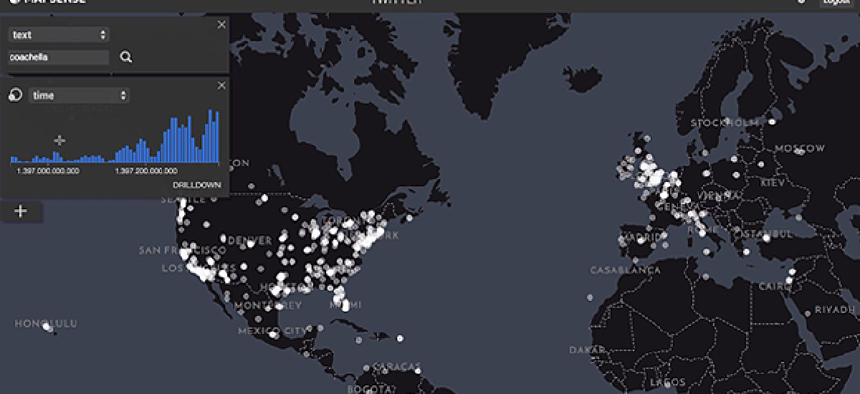
Cohen said his team spent significant time building technologies to be able to visualize those large location data sets. For example, Mapsense utilizes a technique they call "geographical data sampling." When ingesting, say, 100 million tweets from a customer's data stream, the program display a subset that is representative of the spatial distribution of the overall set. Further data will only be sent when requested by, for example, zooming in. "We continue to perform the density sampling as you zoom in," Cohen said.
Data streams from customers may be updated in real time or at specified time intervals. Mapsense will ingest the data as it comes in, then port it to the interactive map.
In addition to supporting location searches on Twitter feeds, customers can also perform text searches and filter tweets by time, language or a wide array of attached metadata, such as the number of followers of a specific tweeter.
And, of course, Twitter data is far from the only location-sensitive data stream Mapsense can handle. The program has been used, for example, to analyze data from sensors attached to California condors, a protected species. The program is set to poll sensors for the positions of birds every 15 minutes. "You can see that they move north in the hot months," Cohen said. "We can actually play back the position of each bird over time."
Apart from the ability to handle massive amounts of data quickly, Cohen stresses that Mapsense's streamlined user interface means customers don't need to have a much GIS or data-visualization training.
Increasingly people who are not traditional GIS analysts need to make decisions based on location data," Cohen said. "So instead of exposing traditional GIS functionality in a desktop application, we are building everything around [application programming interfaces] that can be built into products.
Mapsense is also trying to cultivate an expanding base of developers and public datasets. The company is offering free access to developers for up to 1 million map queries per month. Developers and customers alike have access to a growing body of datasets, including Open Street Maps, Twitter, the U.S. Census, global earthquake data, world airports, urban crime data and Mapsense’s own curated world and demographics maps.
Users also are encouraged to upload new public datasets. "If you can get your local crime data, for example, you can upload the data," Cohen said. "So that is hopefully a way we can help ingest lots of data around the world."
Cohen stressed that while public datasets are available to all, data provided by enterprise customers is available only to those customers.
Mapsense does not as yet have any federal clients, though the company is talking with intelligence agencies. "We are in discussions," Cohen said. "We really see the potential for government uses, though the government world moves very slowly."
NEXT STORY: NATO outlines IT modernization


