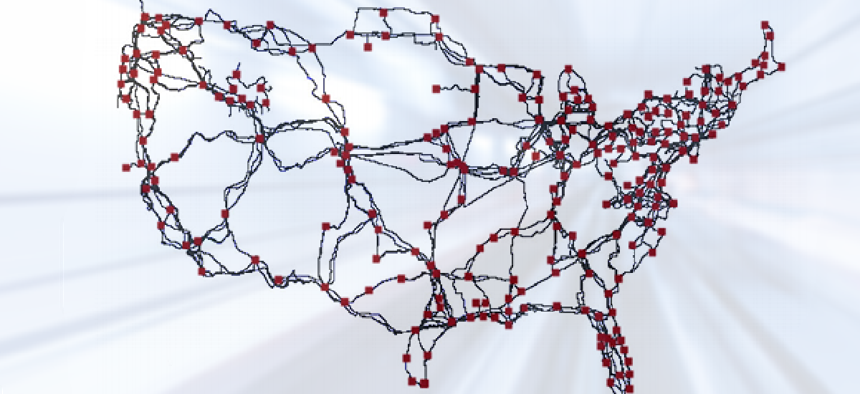
Internet map shines a light on capacity and security


Connecting state and local government leaders
Built over four years, the fiber optic cable map of the United States details the paths of tier-1 ISPs and major cable providers.
While Internet access is nearly ubiquitous in the United States, knowledge of where its wires and cables were actually located remained hidden – until now.
It took several researchers four years to piece together a fiber optic cable map of the United States from a variety of public sources, including tier 1 Internet service providers, major cable providers and public records from federal, state and municipal agencies.
“Our intention is to help improve security by improving knowledge,” said University of Wisconsin computer science professor Paul Barford, one of the researchers. “I think the map highlights that there are probably many opportunities to make the network more robust,” he told the MIT Technology Review.
While the Internet is publicly accessible, its physical, wired backbone is built from many privately owned interoperable networks. Knowing the location of these cables should help better manage and provision the network and reduce risks from natural disasters or intentional attacks, the researchers wrote in their report. Additionally, mapping the current infrastructure shows where new links could be deployed to improve performance and better harden the network against failures.
Among the paper’s findings:
- Long-haul fiber routes tend to run along roadway and railway infrastructures.
- There is a “significant amount” of infrastructure sharing in installed conduits. Although sharing is less expensive for the ISPs than constructing new conduits, the authors found that it risked both connectivity and usage because damage to a major conduit would affect several ISPs.
- Risk and latency could be reduced by deploying new links along previously unused transportation corridors and rights-of-way.
- Addressing a subset of high-risk links is sufficient to improve the overall robustness of the network to failures.
Not everyone agrees with the authors’ conclusions. According to David Wetherall of Google and the University of Washington, the map is “not convincing as an assessment of risks due to shared physical infrastructure,” he said in a review of the report. Because the map includes only the fiber-optic conduits between cities and not wireless or satellite communications, he said, it’s “difficult to assess high-level properties such as risk without combining the map with other kinds of data.”
The map and its data are available through the Department of Homeland Security, Science & Technology Directorate’s Protected Repository for the Defense of Infrastructure Against Cyber Threat. PREDICT is a data repository of Internet infrastructure information available to government and private-sector researchers.


