Interactive bike map helps county get citizen feedback


Connecting state and local government leaders
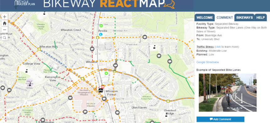
Montgomery County, Md., built an interactive map that lets users see planned bike routes and comment on different sections of the project.
Local government public hearings are rarely well attended. So when Montgomery County, Md., was looking for feedback on a large bike infrastructure project, it turned to an interactive online option.
“The Planning Department historically holds public hearings as the primary way the public can weigh in on a plan before approval,” GIS Manager Christopher McGovern told GCN in an email. “We know that we are not getting a complete cross section of our constituents at these in-person events.”
The county's solution is the Bikeway ReactMap that lets users see the planned bike routes and comment on different sections of the project. The map highlights road segments that are subject to change under the proposed plan in orange, red, green and blue -- each color signifies a different type of bike lane or path.
These comments will be taken into consideration by planners when finalizing the plan.
The GIS layer that users see in the application is the same one used by county planners and the County Department of Transportation, McGovern said.
“Every subsequent master plan effort will overlay this layer within its study area and evaluate it for each new plan,” he said. “As approved segments are built, the layer is updated.”
The county modified the Esri Citizen Science Reporter app to make this tool. It stitched together GIS layers on streets and trails to create what users see in the map.
The map doesn't just show where changes will be made, but it also tells users how proposed changes will affect the “stress” cyclists experience from other traffic, which helps determine how “bikeable” the street is now and provides an estimate of what it will be after the project is complete.
The county is currently using the same tool for feedback on transit-oriented development around the Grosvenor-Strathmore Metro station area, and McGovern said sees it being useful in the future.
“I anticipate using this application for many more of our upcoming plans,” he said.


