Tracking the Blanket of Unhealthy Air in the Pacific Northwest

Washington Smoke Information
While real-time data can’t clear the air of wildfire smoke, it can help people and agencies make smarter decisions.
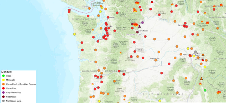
SEATTLE — The Puget Sound region in Washington state generally enjoys very good air quality thanks to its maritime geography. But wildfire smoke, much of it blowing south from British Columbia, and stagnant weather conditions have caused a dirty blanket of air to sit over the city in recent days.

Air quality monitors in and around Seattle recorded unhealthy levels on Tuesday. Conditions have been even worse over the Cascade Range in central Washington, where local wildfires along with the smoke from Canada sent air quality levels into hazardous territory in Entiat and Wenatchee.

Exposure to wildfire smoke is not healthy, especially for vulnerable populations including the elderly, pregnant women and those with cardiac or respiratory conditions. Public health officials have urged those populations to limit their outdoor activity and take other precautions. In some areas where air quality is worse, authorities have urged everyone to limit their outdoor activity.
While the wildfire smoke is expected to start to blow out of Seattle later on Wednesday, other parts of the Pacific Northwest, especially in the interior, will continue to face degraded air quality this week.
While real-time air quality data can’t improve the air quality, it can help people—especially vulnerable populations—stay informed and take precautions. The Washington Department of Ecology relays users to this smoke information portal, which is part of data collaboration among multiple county, state, federal and tribal agencies.

Exploring an air quality map from the Puget Sound Clean Air Agency on Tuesday after, a monitor at 10th Avenue and Weller Street in Seattle’s International District reported readings for fine particles, measured in micrograms per cubic meter, in the unhealthy territory, along with the track of the one-hour averages. Under the impact bar, a risk grid is displayed for sensitive groups and healthy adults along with a recommendation: “Stay indoors today.”

In Oregon, the state has an air-quality app called OregonAir that uses emoji to note where there’s good and bad air quality or “meh” average conditions. The Statesman Journal reported that the Oregon Department of Environmental Quality revamped its air quality platform after last year’s fire season, when heavy use caused it to crash.
Michael Grass is Executive Editor of Government Executive’s Route Fifty and is based in Seattle.
NEXT STORY: Las Vegas Wants to Find Problems With Its ‘Smart City’ Systems Faster


