Aerial photos best satellite imagery for Durham public works

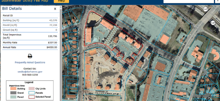
The frequent, high-quality images and a web service map make it easier for Durham, N.C., to bill stormwater runoff fees.
To better map the city -- and track its recent growth boom -- Durham, N.C., replaced its satellite imagery with high-resolution aerial imagery available through the cloud.
Specifically, the city's Public Works Department uses aerial imagery from Nearmap to better map and bill residents and businesses for impervious properties -- those areas such as buildings, pavement and gravel that impede absorbtion of rainfall and result in surface runoff. The money goes to the city’s $16 million-a-year Stormwater Utility Fee fund.
“Right now, we have about half a billion square feet of impervious area that we monitor, and we have to break that out by parcels,” said Durham GIS Administrator Edward Cherry, adding that there are about 90,000 parcels. Without any imagery, the information would have to be assembled from site visits and construction plans.
Previously Durham received satellite pictures every autumn, but now it gets more-detailed imagery every six months. That helps the Public Works Department send more accurate bills, Cherry said, plus it makes the charges clearer.
What’s more, the city built web map services similar to Google Maps that lets stormwater bill payers zoom in to see their properties. “Having clear imagery behind it for someone to zoom in and look at saves us a lot of time,” Cherry said. The map cuts down on customer service calls because people see the email address on the map and send in their comments. “It grabs a screen capture in a PDF form of your property, and you can type in your question or your argument of why you think you’re being overbilled,” he said.
Getting images more frequently has also helped the department navigate Durham’s population and construction growth in the past decade, Cherry said.
“We’ve found it challenging to keep up with the property sales. We’re averaging 700 a month,” he said. Whenever a property is sold, the department has to review the area's previous billing.
Plus, year-old imagery didn't show new construction, which meant one of his 14 staff members would have to go to the site to take measurements. “With multiple flights, we can do this from our desktop,” Cherry said.
Many functions of municipal governments rely on imagery data, said Nearmap's VP of Marketing Tim Frank. For instance, the Shelby County, Tenn., Emergency Communications District is using Nearmap imagery to geocode and plot new addresses and developments into 911 mapping systems to help first responders. Las Cruces, N.M., is applying it to surveys.
Nearmap uses camera systems that sit in fixed-wing aircraft that fly multiple times a year over 70 percent of the U.S. population, Frank said. “When the image is captured, our own patented camera system and processing system are able to stitch it all together with georeferenced data and do so very accurately," he said. "It’s available within days of capture.”
Users log into Nearmap’s browser-based mapping tool called MapBrowser to access the imagery. They drill down to details such as addresses and take measurements that are accurate to within inches. Users all have their own logins, and although they can’t edit the maps in the cloud, Nearmap integrates with GIS tools such as Esri ArcGIS so that users can make changes locally.
Nearmap stores the imagery indefinitely, so users can access the most recent as well as historical captures.
Next, Durham plans to use the imagery to help predict degradation of city-run roadways. In September, Durham conducted a pavement condition index survey with high-resolution photos of stress points in streets using a camera on car bumper. The images were then tied to coordinates on a map. In the future, Cherry said he wants to eliminate the need for such drives by using aerial imagery to identify stress areas in the roadways and confirm predictions of where problems will occur.


