When simple is best: Google Maps for disaster prep


Connecting state and local government leaders
By using the popular navigation app, Los Angeles can deliver an inexpensive, easy-to-use tool for residents that also reduces the number of emergency calls.
To prepare residents for natural or manmade disasters, the Los Angeles’ Information Technology Agency (ITA) is using a tool many Angelenos already use on a regular basis to check traffic or get directions: Google Maps.
The city first turned to the world’s most popular navigation app in the winter of 2016, when the “Godzilla El Nino” weather system threated to soak California. As officials considered what residents needed to be prepared, the answer was they needed to know where to find things -- hardware stores, shelters and food banks, for example.
“The more we discussed this, the more we realized that really what we were describing was a map, ITA General Manager Ted Ross said. Google Maps provides the full package, allowing users to see their current locations via their phones’ GPS, and ITA was able to add layers with application programming interfaces. For instance, an API from the National Weather Service could show where the storms were headed, a Google API layered on locations of hardware stores and sandbags, and an API from a utility company showed power outages.
That El Nino fizzled with no major problems, but when the Skirball Fire struck the city last winter, ITA turned to the map again. The mayor’s office ordered evacuations that would affect about 150,000 of the city’s 4 million residents and asked ITA for a digital way to quickly get the information out.
“We took Google Maps, and within an hour or so the city had the evacuation area clearly identified, we had evacuation centers, we had evacuation centers for animals,” Ross said. “You don’t have to be an expert at reading maps. You can very clearly see if you’re in the evacuation area or outside the evacuation area.”
Within 36 hours, the map had 3.5 million views, a clear indication of its effectiveness, he said. One reason for that success is that Google Maps is something people are familiar with. “It’s always important, I think, for government to go where people are than to create something in which you try to draw the people to government,” Ross said.
Additionally, it’s highly intuitive, and ITA kept the information to a minimum, as opposed to overwhelming users.
“We sometimes tend to over-engineer: 'Let me give you 60 layers, look how powerful this is,'” Ross said. “I don’t think those Angelenos were looking for a powerful, complicated solution. I think they just wanted to have a few pieces of information that were reliable delivered to them in an easy-to-use format.”
For the city, Google Maps is a low-cost way to reach many people quickly. Rather than having to stand up a new solution, ITA saves money by using an existing product, Ross said. Plus, it reduces the number of calls emergency responders need to field, freeing them to focus on more pressing issues.
After the fires were contained, ITA changed the layers on the map to provide information for people who were rebuilding their homes, for instance. “We try to think through the life cycle of a disaster,” Ross said.
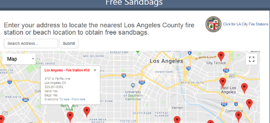
More recently ITA adapted the map to create a page called Storm Watch that has links for residents to register for emergency alerts, request city services and find free sandbags and homeless shelters. It also has weather predictions and rainfall expectations over the next 24 hours.
ITA also has prebuilt pages for fires and earthquakes that are ready to deploy. On Nov. 2, Earthquake Watch reported that there had been 14 quakes stronger than 1.0 in the past 24 hours, with the strongest registering 1.8 and located 10 miles northwest of California City. Pins on a map showed the locations of other temblors, and a color-coded key indicated quake strength.
“We see it as applicable to any natural or manmade disaster -- any time you need to convey to a large number of people what resources are available,” Ross said. “It’s kind of like a first-aid kit. The more you can have it available and ready to go when you need it, it’s just one less thing that you have to think about.”


