The pickup truck that’s driving climate data monitoring


Connecting state and local government leaders
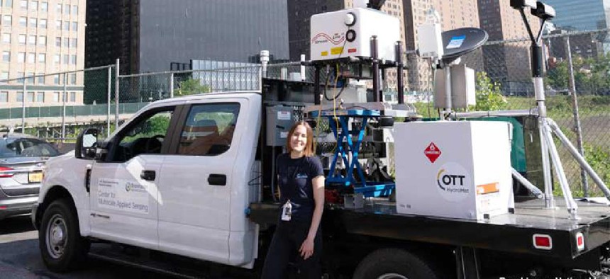
The Center for Multiscale Applied Sensing at Brookhaven National Laboratory’s has outfitted a pickup truck with atmospheric monitoring instruments so researchers can easily relocate their sensing and analysis equipment as they study urban microclimates.
Climate scientists from Brookhaven National Laboratory’s Center for Multiscale Applied Sensing (CMAS) have outfitted a pickup truck with their atmospheric research and monitoring equipment so they can capture precise, local data on wind, temperature, rain, and clouds in different areas of a city.
City neighborhoods – business districts, retail sections, residential areas and parks -- have “unique and uneven responses to climate change,” said Katia Lamer, a research associate in Brookhaven’s environmental and climate sciences department. Lamer and her team want to monitor local weather conditions to identify areas vulnerable to climate change and evaluate mitigation strategies.
While scientists have suspected urban microclimates vary between different areas of a city, collecting and measuring localized high-resolution data has been challenging because of cities’ “highly heterogenous nature and high obstacle density,” Lamer said in a lab news post.
It is expensive and inefficient to install a sensor network across an entire city – or even a neighborhood -- but the CMAS truck carries a variety of atmospheric measurement instruments, including cameras, lidar radar, a navigation system, generators, computers and routers for accessing high-speed internet. The completely independent platform can relocate its sensing and analysis equipment quickly and easily.
“This design allows us to study large-scale changes in temperature and rainfall between the city center and the suburbs and also smaller-scale changes between neighborhoods,” Lamer said. “Understanding these differences brings us one step closer towards achieving environmental equity for all city dwellers.”
In June, researchers drove the CMAS pickup from Brookhaven Lab in central Long Island to Manhattan to collect data to help understand air flows around skyscrapers. On two separate days, they parked on each of the four sides of a single skyscraper, adjusting their position throughout the day as atmospheric conditions changed.
“Air flow around buildings is something scientists do not fully understand, yet it has a huge impact on how pollutants and heat travel through the air and, as such, on the conditions experienced by pedestrians at street level,” Lamer said.
To monitor wind patterns above ground level, the research team used the mobile observatory’s fisheye camera to guide a scanning Doppler lidar measuring the movement of particles in the air.
“The use of multiple remote sensors exchanging data in real time through a high-speed internet signal is a new way of operating lidars for improved pointing accuracy,” Lamer said. “This significantly helps with collecting data between buildings, which otherwise would completely block our instrument signals.”
The team also measured local winds and temperatures as they traveled from the Brookhaven campus to lower Manhattan to identify the boundaries and characteristics of the city’s heat dome. When they’re done gathering data in Manhattan, the researchers plan to take the truck to cities across the U.S.
“Each city has its own unique urban environment,” Lamer said. “New York City has a subway system, which has air moving in and out of underground tunnels, and the city is coastal, so it feels the effect of the sea breeze. Houston, in contrast, does not have an underground subway system and has smaller buildings. As such, it should have a different urban atmospheric structure.”
While the researchers hope to add more monitoring equipment to the CMAS truck, they’re also getting requests from other scientists to put their instruments on the pickup. “It feels like this experiment will become a community platform, and we look forward to growing into new research areas,” Lamer said.


