Robots stand guard on bridges and ports


Connecting state and local government leaders
The attributes of precision, repetition and scale make robots ideal for tackling one of the country's biggest economic challenges: maintaining the deteriorating infrastructure of the U.S. highway system.
The attributes of precision, repetition and scale make robots an ideal technology for tackling one of the country’s biggest economic challenges, expert say: maintaining the deteriorating infrastructure that threatens the integrity of the U.S. highway system.
Indeed, a whole species of camera- and sensor-equipped robots has has been built to monitor and measure things in difficult to reach places.
“As a sensor platform, I see a lot of advantages to robots, whether they are tethered or untethered, drones or crawlers or walkers, for places where inspectors have difficulty getting to or places that are dangerous,” said Joey Hartman, director of the Federal Highway Administration’s Office of Bridges and Structures.
“Climbing a big bridge is a very difficult thing for an inspector. So I can see robotic devices taking over,” he told GCN.
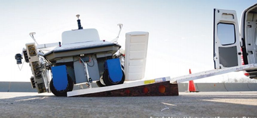
In fact, Hartman’s office is conducting trials with the Robotics Assisted Bridge Inspection Tool (RABIT), a device about the size of a Volkswagen beetle that can cover 4,000 square feet of bridge deck per hour.
The RABIT carries high-resolution cameras and sensors that measure electrical resistance (to measure corrosive materials in the concrete), impact echoes and ultrasonic surface waves (to evaluate concrete delamination and deck strength). The device also uses ground-penetrating radar to map rebar and other metallic objects. Finally, the RABIT has GPS that records and marks location data.
The data collected by the RABIT is transmitted wirelessly to a computer in an accompanying van for engineers and inspectors to process. “The robot is not smart,” Hartman noted. “It's not reading data and then using that to make decisions about how it is interrogating the bridge deck.”
But the RABIT does add terabytes of valuable data that previous methods of inspection couldn’t deliver. “We still drag chains on top of a bridge. And based on years of experience, a bridge inspector would understand how the resonance that was caused by the chain dragging could indicate areas of delamination, areas in the concrete where splitting is occurring and where a more detailed evaluation may be needed,” Hartman said.
While the RABIT is still in the development stage, it is being used on 24 bridges in six mid-Atlantic states. Over the next five years, the agency plans to use RABIT to scan up to 1,000 bridges across the nation.
“The biggest hurdle is to understand how the data collected by RABIT can be turned into information and how to make that information actionable,” Hartman said. “I suspect there are a couple of Ph.D.s in the room who eventually have to look at that image to understand it. We still have some development to do.”
Hartman said the agency also inspects bridges under water, and that a robot is in development that would eliminate sending human divers into potentially hazardous situations.
Undersea monitoring
The Transportation Department is, of course, not the only department using robots for infrastructure inspection. The Department of Homeland Security is pursuing a variety of robotic monitoring capabilities.
One of the more exotic is the BIOSwimmer, a life-size replica of a tuna being developed by Boston Engineering Corp. under contract to DHS’ Science and Technology Directorate.

The battery-powered robot is designed for either tethered or untethered operations, and it can be outfitted with different sensors, including optical and pencil-beam radar. According to DHS, the device can be used to inspect the interior voids of ships, such as flooded bilges and tanks, as well as hard-to-reach external areas such as steerage, propulsion and sea chests. It can also inspect and protect harbors and piers, perform area searches and, “carry out other security missions.”
While submersible and ground-level robots are staffing public works projects, bots that are not much more than aerial sensor platforms are also being developed for infrastructure monitoring and evaluation from the sky.
In fact, unmanned aerial systems (UAS) have been already deployed by the U.S. Geological Survey, the Forest Service and the Department of Agriculture to gather data on crops, forest health and environmental issues.
However, the use of UAS as sensor platforms has been held back, especially in urban areas, by the need to develop policies governing their use in the domestic airspace. But most analysts expect that it’s only a matter of time before UAS are cleared to conduct operations inspecting urban infrastructures.
The National Science Foundation’s National Robotics Initiative took a step toward preparing for that day in November 2013 when it awarded a $2 million grant to a group of researchers at Carnegie Mellon University to develop an aerial robot designed specifically for infrastructure monitoring. The team is working to develop small aerial robots that carry 3D imaging and mapping equipment to evaluate the health of bridges, buildings and other infrastructure.
NEXT STORY: Robots step up for government work


