Annapolis Looks to Keep Its History Above Water

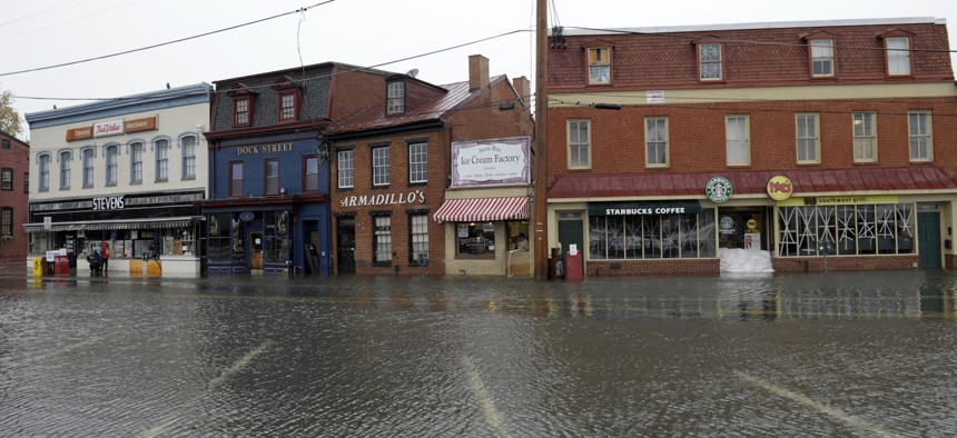
The historic waterfront in Annapolis, Md., is vulnerable to flooding. Susan Walsh / AP File Photo
In Maryland’s capital, confronting rising sea levels means considering irreplaceable buildings that are an important part of the city’s heritage and economy.
Editor’s Note: This is the fourth and final article in a series based on interviews with city officials at the 2017 Resilient Cities Summit. The National League of Cities, the Urban Land Institute, and the U.S. Green Building Council held the event in Stowe, Vermont, July 17 to 19.
Rising sea levels and an upswing in flooding are threatening historic buildings in Annapolis, Maryland—and the city wants to do something about it.
“We have buildings that have been there 300 years,” said Lisa Craig, Annapolis’s chief of historic preservation.
Located at the confluence of the Severn River and Chesapeake Bay, the city is Maryland’s state capital and home to the U.S. Naval Academy. It is prone to both storm surge and river flooding.
Annapolis has identified about 150 historically significant structures located in low-lying parts of town that are considered vulnerable to flood waters. These properties range from the Sands House, built sometime around 1700, to a tavern that once counted George Washington, Thomas Jefferson and Benjamin Franklin among its prominent patrons.
Protecting those buildings from sea level rise and flooding is not only important from a preservation aspect. As Craig explained, heritage tourism is a key economic asset for the city and the local streetscapes are a central part of the “Annapolis brand.”
But some of the city’s postcard views are in areas that, according to Craig, “will disappear by 2100,” based on current sea level rise projections, barring planning and protection efforts.
The city is already seeing changes in the way it is affected by the surrounding waters. Fifty years ago, Annapolis experienced about four days of “nuisance flooding” annually, Craig estimates. Nowadays, it is occurring roughly 40 days each year.
Especially high tides, sometimes combined with heavy rains, can drive this type of flooding. Waters can overwhelm the city’s stormwater system, leaving parking areas submerged and creeping up to the doorsteps of businesses.
“Our pretty urgent need is to address both the long-term issue of sea level rise,” Craig said, “and the shorter-term issue of nuisance flooding and having an improved stormwater management system.”
With these issues in mind, the city has for about four years been working on an initiative known as “Weather It Together.”

As part of this program, Annapolis is adding cultural resources, like historic buildings, into an update of its hazard mitigation plan. In order to be eligible for certain Federal Emergency Management Agency assistance, jurisdictions need to maintain these types of plans.
Annapolis, Craig said, will be the first place in the U.S. to incorporate cultural resources into the plan. A draft is expected to be completed by late this summer.
“Once we have this plan completed, FEMA has indicated to us that they will use it as guidance for other historic coastal communities,” she explained.
Updating the hazard mitigation plan in this way goes beyond looking at the physical loss and damage that could occur to historic property in the event of a disaster like a severe flood or hurricane. It also involves looking at factors like potential losses to the local economy.
For instance, if businesses in the historic district are flooded and have to shut down, what would it cost for them to relocate and lease space elsewhere while the city rebuilds? And what would it mean for local employment? Or for city and state tax revenues?
“The indirect costs and losses associated with a major storm event, or even nuisance flooding, are being calculated through this Weather It Together plan,” Craig said. “We’re going to know what we have to lose and, if we do have a major event, what we can actually report to FEMA.”
What this means is that when it comes time to calculate the amount of federal aid the city might be eligible for in the wake of a disaster, Annapolis does not have to accept a number FEMA may have developed using a standard formula. “We have the real number,” Craig said.
For the historic properties in the floodplain, Craig said losses could total around $228 million.
The city’s efforts to prepare for rising sea levels go beyond the hazard mitigation plan update.
Craig pointed out that the U.S. Army Corps of Engineers has conducted studies looking at flood-related risks in the city and has presented strategies for protecting historic property.
There are also tax incentives for private property owners to take floodproofing measures. An example might be installing “flood vents,” which can prevent damage to a building’s foundation and walls, or terracing the ground around a building to block floodwaters.
The city is also working on a program to improve its stormwater management system. This is slated to involve new pumps, equipment to prevent backflow into the city’s drainage system and other infrastructure upgrades. The city needs about another $10 million to carry out this work.
From Oct. 29 to Nov. 1, Annapolis will host a conference called Keeping History Above Water, which will focus on the risks rising seas pose for historic communities—no small concern for Annapolis and other coastal cities. As Craig noted: “Historic communities are irreplaceable.”
PREVIOUSLY in this Route Fifty series:
Bill Lucia is a Senior Reporter for Government Executive’s Route Fifty and is based in Washington, D.C.

NEXT STORY: Governors pivot to energy, transportation innovation


