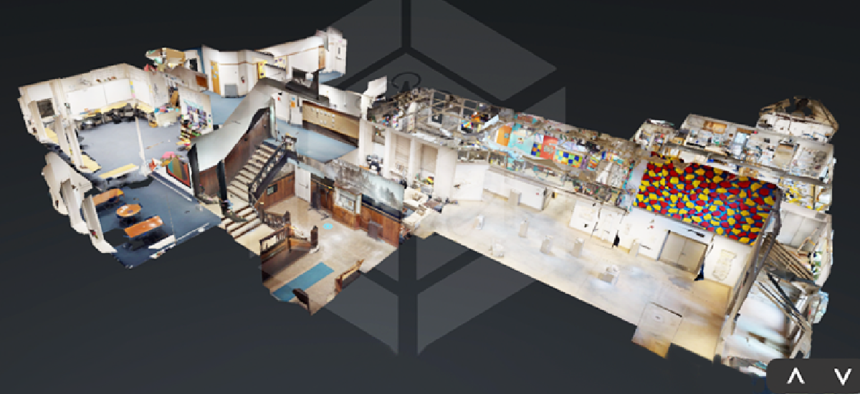
Startup builds 3D models of building interiors for responders

360VR Technology's platform gives responders web-based information about facility interiors proactively -- while they’re en route to the incident and once they’re onsite.
New 3D modeling technology could help first responders stay safe in future emergencies by giving them information about buildings ahead of time.
To create a virtual model of a building, Delaware-based 360VR Technology first walks through a site with a facility or building manager, noting where everything is located, especially key areas such as fire escapes or hazardous materials stores. Then, using native 3D modeling and a scanner, which speeds the process, workers build a model of the facility, tagging all the resources they marked off during the tour.
“When there’s a fire or an emergency or an active-shooter situation, one big issue for firefighters and response teams is that they lack a lot of key building information,” 360VR Co-founder Sury Gupta said. “Oftentimes they have to do a lot of on-the-spot reconnaissance, they have to do a lot of on-the-spot decision-making, they have to scramble to find the people who know about the building so they can guide them.”
The company’s solution would give first responders crucial building information proactively -- while they’re en route to the incident and once they’re onsite.
To access the 3D building models, responders would get a link that they can pull up on a smartphone or squad car laptop.
“We built a web-based platform around the 3D models, which contains all the other information: key notes, maps for the surrounding areas with key external features like hydrants, evacuation zones,” Gupta said.
First responders don’t need any additional equipment, however, to access the models.
“That’s something big that we learned from the firefighters,” Gupta said. “They don’t want to spend all this extra money on more equipment that they are only going to use for one thing. We wanted to have it be as convenient and useful to them as possible, and that meant creating an easy-to-use [user interface] that gets the job done and making it available on any device that has internet access.”
For fires, chemical spills and natural disasters, it's critically important to where people are most likely to congregate in a building for search and rescue operations.
“You have to know how to navigate the building and know where everything is in the building to effectively be able to get in, save the people and be able to navigate out of that building,” Gupta said. “When you’re dealing with natural disasters where you have potential flooding, potential infrastructure breaking down, you should know where things were … because those situations can be dangerous for both the occupants of the building as well as the people going inside to save everyone.”
The company began by making virtual tours for business marketing and real estate agents, but it shifted direction last October after a University of Delaware (UD) professor told Gupta and his partner, James Massaquoi, that they had a good solution but needed to use it to solve an existing problem, rather than look for a problem to solve.
They researched ways to help insurance companies with documentation and discovered risk management -- how buildings are managed and who carries their risk. That, in turn, led them to speak with first responders and start down their current path.
“That helped us to get to where we are, building a solution around their problems and their needs.” Gupta said.
Last month, Gupta and Massaquoia, undergraduates at UD, won the school’s Hen Hatch entrepreneurship competition and will participate in the Summer Founders program through Horn Entrepreneurship, the creative engine for entrepreneurship education and advancement at UD, before seeking investors.
The models will be available for free to first responders, and 360VR will earn revenue from other sources. For instance, this summer, they will look into how the solution can attract business from insurers.
“Hypothetically, if this system can save 10 percent of a building by making firefighters more effective in stopping a fire, that’s a lot of money they save on the insurance side,” Gupta said.
Right now, 360VR is focused on high-risk buildings such as schools, hospitals and other large facilities. It will run several pilots this summer with the UD Police Department and others. For instance, it will map out the school’s Bob Carpenter Center, 5,100-seat multi-purpose arena.
The company will also start to incorporate drone imagery into models and integrate with automatic doors, smart lights, surveillance cameras and internet-of-things technologies. Aerial pictures of outdoor resources such as fire hydrants or escape routes will augment the models’ and the responders’ effectiveness, Gupta said.
The National Institute of Standards and Technology is also supporting the creation of indoor maps of buildings for responders.
In October 2018, NIST's Public Safety Innovation Accelerator Program announced over $750,000 in funding for three local responder agencies to create annotated point clouds and 3D imagery datasets collected from a variety of building types. The data will be used by industry, academics and government agencies and will foster additional research in indoor localization and navigation, as well as other novel indoor location-based services, such identifying indoor architectural features, classifying relevant public safety objects and integrating with augmented and virtual reality technologies for first responder operations.


