Geospatial and the elite


Connecting state and local government leaders

Old-school geographic information systems still dig deep on mapping and analyses.

Yes, Google Earth and Microsoft Virtual Earth have sizzle and pop. With this software, you simulate flying around the globe and zoom down to street level in virtually any major city in the world. You can pirouette around your old high school or look to see whose car is parked out in front of your ex-wife's house. (Though it's not in real time and neither product can yet let you read the license plate.)But despite all the 3-D sparkle of these Web map tools, if your agency wants to do serious geographic analysis, you're going to need a tool with more muscle.'It's a cool display, but that's what it is ' a display,' Doug Gordon, managing director of MapInfo's product management division, said of Google and Microsoft's offerings.'All you really can do [with those products] is create points and stick them on the globe. You can't offer large quantities of information about land parcels, natural resources or the census. You can't do high-quality cartography,' agreed David Maquire, director of products at ESRI.To do more in-depth geospatial analysis, you're going to need a full-fledged geographic information system, or GIS.GIS solutions offer more than just map displays. They combine the analytical power of databases with the geographic capabilities of maps. As a result, they can produce reports that show at a glance anything from demographic trends to the most appropriate site for a new hospital.The Centers for Disease Control and Prevention, for instance, found that GIS software could reveal trends that might be hard to spot by looking at the numbers alone.The agency uses GIS tools for its Interactive Atlas of Reproductive Health. This Web-based map application ' created using ESRI's family of GIS tools ' can be accessed using a simple browser and lets users search and display a variety of data, such as infant mortality, pregnancy outcome, infant health and maternal risks. Users also can choose to display data in a variety of ways, including by state or census division.'When we built the atlas, it was to address the needs of our family planning constituents, who need this information for health policy service decisions,' said Dabo Brantley, project leader for the Interactive Atlas of Reproductive Health.Already, the atlas has produced striking results, Brantley said. She recalled creating a map analysis that overlaid teen fertility in Texas on a map showing the locations of family planning clinics. The highest fertility rates were right along the state's southern border. What was interesting was that there were no family planning clinics in that area.'We work with the Office of Population Affairs,' Brantley said, 'and they came down and we showed them that map and they just couldn't believe it. You can look at this in tables all day. We have 300 family planning clinics in Texas, but you can't tell where they are. And you can look at an alphabetical listing of counties, but you can't tell how they relate to each other. On a map, it's really striking.'At present, the atlas doesn't have many advanced GIS capabilities. 'It's really just a glorified map book,' Brantley said. By late spring, however, she expects to add tools that will bring true GIS capabilities to the project. 'We're going to take the data we have now, update it with more years [of data], and we're going to add what we call resource layers than you can lay on top [of the maps].'GIS programs have long been used by engineers, transportation planners and other specialists to track and analyze geographically oriented data, from the location and age of utility lines to deforestation trends.The snag was that buying a GIS solution meant spending many thousands of dollars on software and thousands more on high-end workstations and training. In recent years, however, GIS programs have gotten both less expensive and easier to use, encouraging broader use in government for a variety of purposes. Local state and federal agencies have used GIS software to execute such tasks as:A variety of advanced tools give GIS programs such as those offered by MapInfo and ESRI the ability to perform such tricks.Suppose, for example, you want to determine the resources available along hurricane evacuation routes in Louisiana.Using the buffer tool in MapInfo Professional or ESRI ArcView, you would first select those routes and then create a buffer five miles wide on each side of the routes. You can then search within that area for all resources in your databases matching any specified criteria.Buffers aren't, of course, the only analytical tool. High-end GIS solutions can perform line-of-sight analyses that can, for example, aid in determining obstacles for radio waves or air traffic. Routing tools let users track mobile assets and calculate the best routes to a destination. Geocoding tools allow data to be attached to geographic features ' such as street addresses, ZIP codes or census tracts ' for subsequent analysis and display.What's more, full-featured GIS programs such as ArcView and MapInfo also offer far more choices when it comes to displaying map data. While Google Earth and Microsoft Virtual Earth let you overlay a layer of data on a map, full-featured GIS systems let you perform multiple overlays and complex data analysis. Want to display crime rates broken down by county or census tracts? You can create theme maps that color-code each sector according to their rates. You can also apply multiple-theme overlays using other characteristics, such as texture, dot density, pie charts or even 3-D extrusions.In addition to the robust set of tools on program menus, full-featured GIS programs offer broad support for both database formats and map projections. That might seem rather dry, but it matters. Without such support you could have huge amounts of data that you want to use but can't.'If you get data from the national map and you have some data in the Texas State Plane Coordinate System from your local database, and you want to combine the two together, you can't do that in Google Earth or Microsoft Virtual Earth because they don't have accurate projection engines,' ESRI's Maguire said.ESRI's ArcView makes it easy to bring in and project such data, he said. What's more, GIS vendors offer scalability to agencies and departments that the Web mapping programs can't deliver.'From a customer's perspective, they almost never come to us and say, 'Tell us about your one product,' ' MapInfo's Gordon said. 'They come to us with a business problem and ask how we would address it. It could be a combination of products.'Both MapInfo and ESRI offer Web browser-based clients and Web server software to deliver content in much the same way as Google Earth and Microsoft Virtual Earth, though with more analytical and display tools.The vendors also offer robust desktop programs for creating more advanced map features, integrating data and performing sophisticated data analysis. Both companies also offer extensive data sets and modules for performing specialized chores, such as 3-D analysis and trade zone analysis.Most advanced GIS programs also are programmable so that you ' or, more likely, a trained consultant ' can create customized applications that more efficiently suit your data analysis and mapping needs.The Department of Homeland Security on March 17 unveiled its own ambitious GIS project: the Infrastructure Critical Asset Viewer. ICAV will be used to coordinate geographic information about the nation's critical infrastructure with emergency response and other security resources.ICAV will provide 'operational, situational and strategic awareness of homeland security-specific mission focus,' said Steven Alness, manager of DHS' Geospatial Programs Office. The system will be used to loop in state, local and other federal agencies as well as private-sector partners.'For instance,' Alness said, 'Hurricane Katrina could be plotted on the map and the code of uncertainty for that hurricane track could be correlated with the nation's infrastructure. It gives you that visual context in a dynamic near-real-time or real-time.'The system will help responders at the federal, state and local level understand threats and vulnerabilities as well as efficiently coordinate responses.Alness added that one great feature of the platform, which was built with ESRI software, is that users can access it using nothing more than a Web browser. At the same time, they'll have access to sophisticated GIS tools, such as distance plotting and address matching.The power of the GIS application, said Alness is that it helps tie together mission-specific elements to give a 'total common operating picture.'

The geospatial line of business

Geospatial products and services got quite a boost in the White House's 2007 budget request, which included a proposal for establishing a Geospatial Line of Business. By establishing an LOB, the Office of Management and Budget is fundamentally encouraging agencies to expand implementation of geospatial technologies.

Already, the effort has resulted in the completion of a 'Joint Business Case and Common Solutions/Target Architecture' document to help guide agency efforts. In addition, a working group, Senior Agency Officials for Geospatial Information, has been formed.

The Geospatial LOB has outlined a series of next steps, including:


  • Productive intergovernmental collaboration for geospatial-related activities and investments across all sectors and levels of government
  • Optimized and standardized common geospatial functions, services, and processes that are responsive to customers
  • Cost-efficient acquisition, processing and access to geospatial data and information
  • Completion and analysis of a budget data request detailing federal geospatial investments
  • Reporting and analysis of plans for completion of OMB Circular A-16 data layers
  • Completion of a program management plan for the LOB initiative
  • Establishing a project management office to support LOB activities and deliverables
  • Identification of National Geospatial Advisory Committee.

For more information, go to GCN.com/752.

'Patrick Marshall

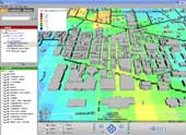
EXTRA LAYERS: MapInfo Professional lets you build varied demographic profiles of citiies such as Washington.

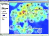
HEALTH TRACK: Health agencies can use programs such as ESRI ArcView to keep track of vaccine points of distribution, such as this example from several counties in Georgia.


More than a pretty face


  • Track the incidence and location of gang crimes to help prioritize resources.
  • Analyze demographic data to select optimal sites for neighborhood service centers or new elementary schools.
  • Analyze accident data to select the best site for an emergency room.
  • Track the location of emergency-response vehicles to help speed their dispatch.


Agency cartography


NEXT STORY: Geospatial for the cheap

X
This website uses cookies to enhance user experience and to analyze performance and traffic on our website. We also share information about your use of our site with our social media, advertising and analytics partners. Learn More / Do Not Sell My Personal Information
Accept Cookies
X
Cookie Preferences Cookie List

Do Not Sell My Personal Information

When you visit our website, we store cookies on your browser to collect information. The information collected might relate to you, your preferences or your device, and is mostly used to make the site work as you expect it to and to provide a more personalized web experience. However, you can choose not to allow certain types of cookies, which may impact your experience of the site and the services we are able to offer. Click on the different category headings to find out more and change our default settings according to your preference. You cannot opt-out of our First Party Strictly Necessary Cookies as they are deployed in order to ensure the proper functioning of our website (such as prompting the cookie banner and remembering your settings, to log into your account, to redirect you when you log out, etc.). For more information about the First and Third Party Cookies used please follow this link.

Allow All Cookies

Manage Consent Preferences

Strictly Necessary Cookies - Always Active

We do not allow you to opt-out of our certain cookies, as they are necessary to ensure the proper functioning of our website (such as prompting our cookie banner and remembering your privacy choices) and/or to monitor site performance. These cookies are not used in a way that constitutes a “sale” of your data under the CCPA. You can set your browser to block or alert you about these cookies, but some parts of the site will not work as intended if you do so. You can usually find these settings in the Options or Preferences menu of your browser. Visit www.allaboutcookies.org to learn more.

Sale of Personal Data, Targeting & Social Media Cookies

Under the California Consumer Privacy Act, you have the right to opt-out of the sale of your personal information to third parties. These cookies collect information for analytics and to personalize your experience with targeted ads. You may exercise your right to opt out of the sale of personal information by using this toggle switch. If you opt out we will not be able to offer you personalised ads and will not hand over your personal information to any third parties. Additionally, you may contact our legal department for further clarification about your rights as a California consumer by using this Exercise My Rights link

If you have enabled privacy controls on your browser (such as a plugin), we have to take that as a valid request to opt-out. Therefore we would not be able to track your activity through the web. This may affect our ability to personalize ads according to your preferences.

Targeting cookies may be set through our site by our advertising partners. They may be used by those companies to build a profile of your interests and show you relevant adverts on other sites. They do not store directly personal information, but are based on uniquely identifying your browser and internet device. If you do not allow these cookies, you will experience less targeted advertising.

Social media cookies are set by a range of social media services that we have added to the site to enable you to share our content with your friends and networks. They are capable of tracking your browser across other sites and building up a profile of your interests. This may impact the content and messages you see on other websites you visit. If you do not allow these cookies you may not be able to use or see these sharing tools.

If you want to opt out of all of our lead reports and lists, please submit a privacy request at our Do Not Sell page.

Save Settings
Cookie Preferences Cookie List

Cookie List

A cookie is a small piece of data (text file) that a website – when visited by a user – asks your browser to store on your device in order to remember information about you, such as your language preference or login information. Those cookies are set by us and called first-party cookies. We also use third-party cookies – which are cookies from a domain different than the domain of the website you are visiting – for our advertising and marketing efforts. More specifically, we use cookies and other tracking technologies for the following purposes:

Strictly Necessary Cookies

We do not allow you to opt-out of our certain cookies, as they are necessary to ensure the proper functioning of our website (such as prompting our cookie banner and remembering your privacy choices) and/or to monitor site performance. These cookies are not used in a way that constitutes a “sale” of your data under the CCPA. You can set your browser to block or alert you about these cookies, but some parts of the site will not work as intended if you do so. You can usually find these settings in the Options or Preferences menu of your browser. Visit www.allaboutcookies.org to learn more.

Functional Cookies

We do not allow you to opt-out of our certain cookies, as they are necessary to ensure the proper functioning of our website (such as prompting our cookie banner and remembering your privacy choices) and/or to monitor site performance. These cookies are not used in a way that constitutes a “sale” of your data under the CCPA. You can set your browser to block or alert you about these cookies, but some parts of the site will not work as intended if you do so. You can usually find these settings in the Options or Preferences menu of your browser. Visit www.allaboutcookies.org to learn more.

Performance Cookies

We do not allow you to opt-out of our certain cookies, as they are necessary to ensure the proper functioning of our website (such as prompting our cookie banner and remembering your privacy choices) and/or to monitor site performance. These cookies are not used in a way that constitutes a “sale” of your data under the CCPA. You can set your browser to block or alert you about these cookies, but some parts of the site will not work as intended if you do so. You can usually find these settings in the Options or Preferences menu of your browser. Visit www.allaboutcookies.org to learn more.

Sale of Personal Data

We also use cookies to personalize your experience on our websites, including by determining the most relevant content and advertisements to show you, and to monitor site traffic and performance, so that we may improve our websites and your experience. You may opt out of our use of such cookies (and the associated “sale” of your Personal Information) by using this toggle switch. You will still see some advertising, regardless of your selection. Because we do not track you across different devices, browsers and GEMG properties, your selection will take effect only on this browser, this device and this website.

Social Media Cookies

We also use cookies to personalize your experience on our websites, including by determining the most relevant content and advertisements to show you, and to monitor site traffic and performance, so that we may improve our websites and your experience. You may opt out of our use of such cookies (and the associated “sale” of your Personal Information) by using this toggle switch. You will still see some advertising, regardless of your selection. Because we do not track you across different devices, browsers and GEMG properties, your selection will take effect only on this browser, this device and this website.

Targeting Cookies

We also use cookies to personalize your experience on our websites, including by determining the most relevant content and advertisements to show you, and to monitor site traffic and performance, so that we may improve our websites and your experience. You may opt out of our use of such cookies (and the associated “sale” of your Personal Information) by using this toggle switch. You will still see some advertising, regardless of your selection. Because we do not track you across different devices, browsers and GEMG properties, your selection will take effect only on this browser, this device and this website.