The many ways government tech is aiding in disaster relief


Connecting state and local government leaders
Imagery, datasets and applications have been enlisted in the response to the earthquake in Nepal.
Recent disasters such as the earthquake in Nepal or the Ebola outbreak in West Africa have brought renewed calls for technology to support search and rescue as well as streamlining communication among first responders.
Earthquake in Nepal
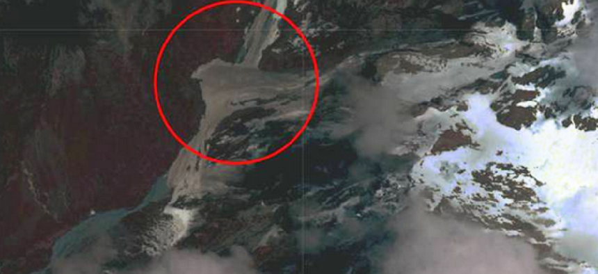
The image above, taken April 27, shows the site of a potential landslide blocking a stream in the Gorkha District of Nepal. It is an example of the kind of tools that are being used to target recovery efforts and speed assistance.
The government technology community has responded in force -- with data, satellite imagery and applications:
The National Geospatial-Intelligence Agency has created an public website in to host unclassified geospatial intelligence data, products and services in support of U.S. and international relief efforts following the Nepal earthquake. NGA launched its website the day after the earthquake, sharing the platform it used for its Ebola support site, which launched in October 2014. Both use Esri’s ArcGIS platform and are hosted by Amazon Web Services. The Nepal portal hosts search and rescue atlases covering Kathmandu and six other affected areas, with maps, imagery and data overlaid to assist rescuers and relief planners. Other products and data layers will be added as they become available, NGA said.
NGA also is providing direct support to disaster relief and humanitarian organizations through the All Partners Access Network, through which the Defense Department shares unclassified information with non-military organizations around the world.
NASA said it is supplying optical and radar satellite data pulled from a number of domestic and international partners and compiling them into a variety of data "products." These include vulnerability maps and damage proxy maps that can tag danger zones and determine the extent of existing damage in other areas.
In addition to the imaging data, NASA said it has also dispatched a new ground-based portable radar sensor called FINDER (Finding Individuals for Disaster and Emergency Response), which can locate people buried as deep as 30 feet below crushed materials and 20 feet below solid concrete, based on their heartbeats and breathing patterns. The technology was developed by the Department of Homeland Security's Science and Technology Directorate.
The data gathered by satellite will be used to create risk models and assess infrastructure damage. The data can also be used to see into remote areas where landslides, river damming and avalanches might complicate recovery efforts.
A joint initiative between NASA and the U.S. Agency for International Development, meanwhile, integrates satellite observations, ground-based data and forecast models to monitor and forecast environmental changes and to improve response to natural disasters. The project, called SERVIR, originally began in 2004 as a collaborative effort that also included the World Bank and the Central American Commission for Environment and Development. And new software, developed by two summer interns, now makes it possible for the SERVIR team to segment the large disaster images into subsets or ‘tiles’ that can be transmitted to recipients in in Nepal, where bandwidth is currently limited. Then the software reconstructs the pieces on the recipient’s side, where the images can be printed.
Earlier this year, the U.S. Geological Survey released several sets of data collected on land elevations in India in order to help scientists better understand and monitor rising sea levels. The data was also made available for public viewing via the USGS’s Earth Explorer website. It is believed that the release and examination of these image data sets will assist in preparedness for droughts, glacial retreats, flooding, landslides and coastal storm surges.
In light of the disaster in Nepal and others such as Hurricane Sandy, the White House has announced several new ideas, tools and initiatives under America’s PrepareAthon! and National Day of Action, which is aimed at “encouraged entrepreneurs, makers, technologists, and creative #DisasterTech innovators to get involved, unleash innovation.”
Examples of new initiatives announced include the Department of Health and Human Service’s GeoHEALTH platform, which features interactive mapping to support agencies and community organizations in preparing for the health impacts of emergencies.
GeoHEALTH pulls data from the National Oceanic and Atmospheric Administration, the Geological Survey and the Centers for Medicare and Medicaid, according to the White House.
USAID developed MapGive, billed as the largest and most complex mapping activation, which began as a response to the Ebola crisis in West Africa. MapGive lent imagery services to the most effected regions such as Liberia and Sierra Leone to help those on the ground coordinate efforts.
And on the research front, the Defense Advanced Research Projects Agency hosted a robotics challenge to test solutions that can be applied in natural disasters. The teams were tasked with building robots that could navigate unpredictable environments with several barriers as to simulate rescue efforts in the aftermath of a natural disaster. DARPA hopes to leverage the successful ideas showcased in the competition for the future of autonomy and disaster response.
Mark Rockwell and Kevin McCaney contributed to this report.
NEXT STORY: 5 steps to building a microservices foundation


