DHS delivers geospatial data as a service for first responders


Connecting state and local government leaders
The Department of Homeland Security pushes remote sensing imagery and GIS data through Terra Pixel to provide information to first responders.
Getting information quickly into the hands of emergency officials is crucial during a disaster, so the Department of Homeland Security increasingly stores its geospatial data in the cloud and provides easy access to location-based imagery for state and local first responders.
Using the imagery-hosting web service called Terra Pixel, DHS can upload, manage, store and deliver data to those first responders so they can see imagery from the past 24 hours, according to Mike Donnelly, a geospatial data architect in DHS' Geospatial Management Office.
Administrators at DHS headquarters can sort the different types of geospatial data coming in from all parts of the government, upload and store it onto Terra Pixel and make it quickly and readily available across the Homeland Security enterprise, Donnelly explained at a session at the Amazon Web Services Government, Education and Nonprofit Symposium.
Terra Pixel is a platform as a service offering that makes available location-based and searchable geospatial information using Amazon Web Service’s cloud storage infrastructure. The AWS platform lets government agencies upload, manage and share unlimited amounts of data on Terra Pixel, which is accessed through the web browser using AWS back-end web services.
The cloud solution not only gave DHS a place to put the data, but also a way to make sure the data was discoverable and accessible to its customers. Donnelly said his agency wanted the “folks on the ground managing situations or responding to incidents to have the same information we have at the headquarters level."
Collected imagery is sent to DHS when an incident is emerging or has just happened, and Terra Pixel is used to transfer that data with GIS-based information to personnel on the ground, so responders can see the incidents happening nearest to them when they access the platform.
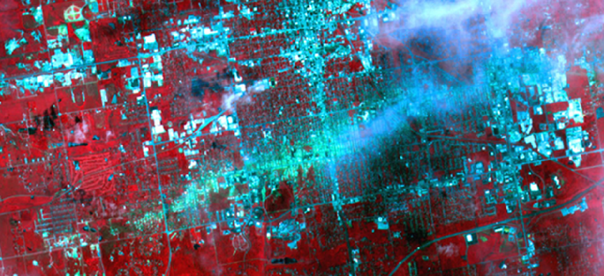
When a 2011 tornado hit Joplin, Mo., for example, Terra Pixel hosted imagery from satellites deployed by the National Oceanic and Atmospheric Administration. DHS opened the data to the Federal Emergency Management Agency and the American Red Cross in Missouri, increasing situational awareness for responders on site.
The service can also be accessed on a mobile device and is available off-line so disconnected users can still access up-to-date maps through Amazon’s Mobile Server integration service.
Because DHS is a consumer of data, it looks for easy-to-use tools to coordinate, discover and resource information quickly, Donnelly said. “We want to leverage what’s out there, we don’t want to recreate the wheel."


