Low-Lying Boston’s Frigid Flood Risk Reminder

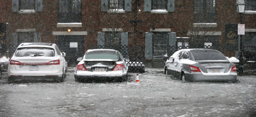
Water from Boston Harbor floods Long Wharf during Thursday as a powerful winter storm moves up the East Coast. Michael Dwyer / AP Photo
A powerful Nor’easter storm brought some of the highest tides on record to Massachusetts—and they’re a taste of what’s to come.
Boston Harbor and other coastal areas in New England saw some of their highest tide levels on record on Thursday as a wicked and rapidly intensifying winter storm meteorologists have described as a “ bomb cyclone ” moved up the East Coast bringing blizzard conditions, frigid temperatures and major snowfall to many areas.
As WBUR reported, Thursday’s tides in Massachusetts were the highest since the Blizzard of 1978 , when record high-water levels were recorded in Boston Harbor. In the town of Scituate, about 30 miles southeast of Boston, storm-driven waves breached part a seawall , forcing evacuations.
According to WBUR:
The storm, although it was about 100 miles off Nantucket, had very strong onshore winds blowing the water toward the coastline. The rapid intensification created a lot of wind, which blows the water toward the shore. Add in some big waves, and you have additional water heading for the shoreline.
Those metrological forces can put some low-lying parts of the Boston underwater.
That includes parts of the Seaport District, an area of Boston built on reclaimed land that’s been the focus of major redevelopment in recent years, an effort pushed by late-Mayor Thomas M. Menino as the Boston Innovation District . General Electric relocated its corporate headquarters to the Seaport District from Connecticut and broke ground on a new headquarters campus in the neighborhood last year.
Higher sea levels associated with climate change are expected to send Boston’s high-water records higher in the decades to come, leaving the Seaport District and other low-lying areas of the city more vulnerable to similar weather events.
“If anyone wants to question global warming, just see where the flood zones are,” Boston Mayor Marty Walsh said on Thursday, according to The Boston Globe .
The Climate Ready Boston Map Explorer , built by the city, demonstrates the areas of Boston most at risk to rising sea levels, higher tides and storm-driven surge into the shoreline. Below, water levels are set to the expected high tide mark in the 2030s with a 10 percent annual coastal flood risk, which sends Boston Harbor into many areas of the Seaport District and near the Fort Point Channel, roughly midway between Boston’s central business district and South Boston.

Changing the settings for the 2050s, not surprisingly, shows larger areas of inundation in the same areas and others.

Thursday’s high tides in Massachusetts were just a taste of what’s to come.
Walsh, the Globe reported, said that they were a reminder to developers who need to factor coastal flooding into how their projects are designed and built.
“We agree entirely with the Mayor’s focus on constructing buildings that are protected from storm events such as this. None of our Seaport buildings or roadways were affected by the storm, validating the administration’s prioritization of this important issue,” according to a statement from WS Development, the Globe reported.
Michael Grass is Executive Editor of Government Executive’s Route Fifty and is based in Seattle.
NEXT STORY: Growing Crack in Ridge High Above Interstate Highway Prompts Landslide Concern


