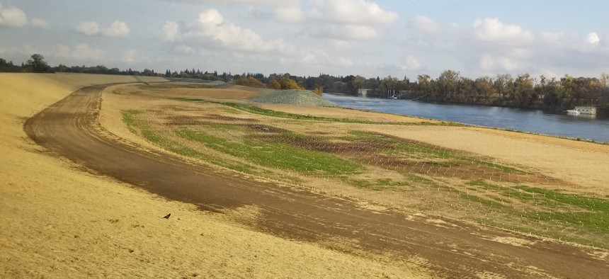
The Need to Accommodate More Floodwaters Near Sacramento

A newly constructed set back levee, at left, in West Sacramento, California was constructed with gaps to allow floodwaters from the Sacramento River to flood the space between the new levee and the old one, at center.. Michael Grass / Route Fifty
A tour of some of the levee infrastructure that protects California’s capital city.
SACRAMENTO — Since the early days of its founding, California’s capital city has dealt with the topographical consequences of its location at the confluence of the American and Sacramento rivers. Local history is intertwined with major flood events and attempts by state and local officials to out-engineer the river systems that cut across California’s vast Central Valley.
During the winter of 1861-62, a 43-day succession of moisture-laden Pacific storms called an atmospheric river flooded much of the Central Valley, including Sacramento, forcing then-Gov. Leland Stanford into a rowboat to reach his inauguration at the California State Capitol. That rainy winter prompted the state government to temporarily relocate to San Francisco until the 10-foot floodwaters subsided a few months later. So much freshwater was draining out of the Central Valley, which was turned into a 300-mile-long inland freshwater sea that incoming tides in San Francisco Bay were temporarily erased.
In response to that flood and many others that followed, leaders in Sacramento built bigger and taller levees and raised the elevation of downtown streets to keep the heart of the capital city dry during high-water events.

Regionally, massive diversion channels, like the Yolo Bypass, were built to accommodate floodwaters, reducing the pressure on the levees that protect downtown Sacramento, that would otherwise be at greater risk of being overwhelmed.

Route Fifty checked out some of the Sacramento area’s flood-protection infrastructure as part of a workshop tour that was part of the Meeting of the Minds annual summit last week.
Newer levees are built with giant concrete walls embedded into the earthen berms to prevent “underseepage,” a term used when water infiltrates the levee through saturated soils. In some cases, the concrete walls go down 100 feet, requiring special construction equipment.
Flood protection authorities, like the West Sacramento Area Flood Control District, are currently engaged in projects to protect local jurisdictions from a 200-year flood event and meet more stringent state and federal construction standards.

Officials from the local West Sacramento district hosted a van tour of one of the newly constructed “setback” levees along the west bank of the Sacramento River. The new giant meandering berm of the Southport Levee—approximately 6 miles long and in some places 1,500 feet in from the existing river-hugging levee—will, with holes punched through the old levee, allow floodwaters more room to spread out in the space inbetween. A riverside road built atop the old levee was relocated as part of the work.
But University of California, Davis applied geosciences professor Nicholas Pinter, one of the tour leaders, noted that even with strengthened flood control infrastructure, “flood risk is not at zero. It’s impossible to get to zero risk.”
West Sacramento flood officials pointed out one of their new challenges with freshly constructed levees: Local residents driving along the new berm with motorbikes and all-terrain vehicles, cutting ruts into the levee’s sloping surface, which could erode under heavy rainfall and weaken the structure. New fencing, signs and camera surveillance are being looked at to deter joyriders from damaging the setback levee.

Flood-depth scenarios for certain hypothetical levee breaks are frightening: According to information from the city of Sacramento, a compromised levee along the Cross-Natomas Canal would fill parts of an area of Sacramento called the Natomas Basin with 16-plus feet of water.
The Natomas Basin is not only home to Sacramento International Airport but also 100,000 residents and 25,000 homes a few miles north of downtown.
It’s a similar scenario to what happened in New Orleans following Hurricane Katrina, when a floodwall breach in the 17th Street Canal sent the waters of Lake Pontchartrain spilling into the low-lying city.

The city has other levee-breach scenarios, evacuation suggestions and flood-depth estimates, including one for the Sacramento River near downtown that floods significant sections of the city. Areas near the State Capitol would be flooded up to 8 to 12 feet and in the Pocket neighborhood, more than 16 feet.

In 2017, the Sacramento Weir, a 102-year-old flood control structure upriver from downtown was opened for the first time since 2005, allowing water from the swollen Sacramento River to spill into the Yolo Bypass, a century-old diversion structure that’s approximately 40 miles long and 3 miles wide.
During a stop at the weir, Timothy Washburn, the former director of planning for the Sacramento Area Flood Control Agency, noted that local efforts to widen the diversion structure to let even more water to spill into the Yolo Bypass.
The challenge is real estate, Washburn said, pointing to the adjacent prime orchard land that would need to be sacrificed.

In July, the U.S. Army Corps of Engineers awarded the Sacramento region $1.8 billion in funding to help local flood control districts complete improvements to levees and related structures to help protect the area from a 300-year flood event. That includes the construction of deeper walls to prevent underseepage and widening the Sacramento Weir.
Michael Grass is Executive Editor of Route Fifty and is based in Seattle.
NEXT STORY: After Complaints About Delays, Federal Transit Administration Announces Grant Awards


