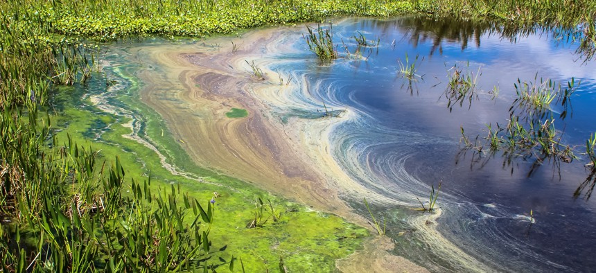
By predicting ‘disgusting algal blooms,’ water district hopes to head off damage

Jaimie Tuchman/Getty images
The South Florida Water Management District is combining its observational data with satellite imagery and Google Public Sector’s Climate Insights to predict the formation of harmful algal blooms.
The South Florida Water Management District is using cloud and artificial intelligence to help scientists predict the formation of harmful algal blooms in key bodies of water.
“We need to really strongly understand water quality, because in 2013, 2016 and 2018, some of our coastal communities—Stuart and then Fort Myers—had some pretty disgusting algal blooms,” said Sean Cooley, director of the district’s Office of Communications and Public Engagement. “That blue-green algae that originated in Lake Okeechobee and was exacerbated by local conditions really ruined those communities’ economies during those summers.”
The 2018 bloom alone affected about 130 miles of coastline, killed 2,000 tons of marine life and cost the state more than $17 million in emergency funding.
The district collects water quality data in three main ways: through permanent stations that automatically send reports at regular, set intervals; from grab samples that workers physically collect; and through anecdotal evidence such as smells and visual reports.
Now, it’s combining that information with satellite imagery for predictive analytics by working with Google Public Sector’s new Climate Insights. Announced in June, the solution uses the Google Earth Engine running on Google Cloud and combines AI and machine learning with geospatial analysis using Google BigQuery, a serverless enterprise data warehouse, and Vertex AI, a unified data and AI platform and tooling for pretrained and custom models.
Processing through Google Cloud millions of images taken every day by NASA, European Space Agency, National Oceanic and Atmospheric Administration, and other satellites, “we can actually start seeing things forming from satellite imagery,” said Franco Amalfi, head of sustainability strategy at Google Cloud’s Global Public Sector. “We can see colors starting to form, and then we know that is where there’s the potential harmful algal bloom that’s forming and where exactly in the lake it’s forming.”
In addition to current imagery, Google has 40 years’ worth of historical data, too, so it can combine that for analyzing with the data that’s updated daily.
“If we look at all the past data, and then we continuously monitor data that comes in through [the district’s] collection and what data comes in from satellites … we can actually start seeing some of the conditions that can actually be impacted,” Amalfi said. “We can get more predictive so that we can better prepare for the future events.”
Currently, district scientists perform quite a bit of manual work downloading images and calibrating the data. Google will automate many of those tasks so that the scientists can focus on science, Amalfi said. “They can actually do a lot more action vs. doing a lot more calculations,” he added.
Plus, much of the current data-collection efforts focus on one thing, such as meeting a reporting requirement, Cooley said. This new process allows the district to bring together all of the state resources that go into environmental restoration and water quality.
“Instead of looking at one body of water or one part of a system for a specific permit need, we’re able to take that data holistically, and with the help of Google, make connections to other publicly available data,” he said. “The thing we’re really excited about, of course, is looking for these trends and things that big data and AI can help identify…. And for us, as restoration managers, we get to say, ‘OK, that's where we need to put a water quality project,’ or ‘That's where we need to influx resources for rapid response,’ or ‘That's where we've got to do more partnerships with those landowners to talk with them about how nutrients are getting into the system.’”
The district, among the world’s largest and most complex water management systems, won’t need to put any foundational technology into place to make this work. The goal is to augment what the agency already has and does, Amalfi said.
Technical work on the project began two months ago, although it was announced last month. Right now, the teams are doing prep work to bring in the data, and Cooley said he hopes it will be ready for use by the state’s next rainy season, which starts in May 2023.
Climate Insights is also being used by the Hawaii Transportation Department to assess and prioritize investments in roads based on climate factors, asset conditions and community impact.
“Our goal is to have a common data-driven platform to collect and share information across agencies, counties and cities,” Ed Sniffen, the department’s deputy director of highways, said in a press release. “This helps us collaborate within our department and engage with our communities so we can better serve the public.”
Google Public Sector is a new division of Google Cloud. Its mission is helping U.S. public-sector organizations accelerate digital transformation. Besides the work with South Florida, the new division is working with other state and local governments. For instance, it helped launch a streamlined unemployment application in New York state and worked with Pittsburgh to transition to cloud-based IT infrastructure.
Stephanie Kanowitz is a freelance writer based in northern Virginia.
NEXT STORY: Some workflows belong in the cloud, others don’t


