Why Are There So Many Sinkholes in Florida?

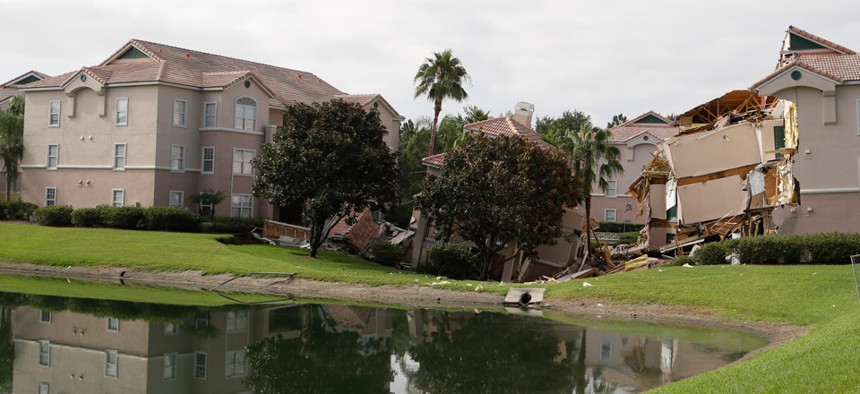
A 2013 sinkhole in Clermont, Fla. damaged three buildings. John Raoux/AP

Connecting state and local government leaders
As pieces of the Sunshine State collapse in on themselves, new technology offers hope for early warning.
The state that’s well known for hurricanes and alligators has another high-profile natural worry on its list: the possibility that the Earth could, at any moment, gobble up a whole neighborhood.
Yes, Florida has more sinkholes than any other state in the nation, according to the local agency that oversees insurance regulations and compliance. Sinkholes have been spotted at least three times in as many months—May in Winter Haven, June in Jonesville, and July in Spring Hill.
One technology that could help: a new remote sensor from NASA to predict sinkhole formations. It's called Interferometric Synthetic Aperture Radar (InSAR), and uses satellites and drones to detect changes in ground elevations over time. Such changes may indicate an area’s vulnerability for sinkholes. Think of it as an ultrasound for Mother Earth.
“Basically, the InSAR technique precisely compares repeat radar observations to measure very subtle deformation of the Earth's surface,” says Ronald Blom, a geologist with the Jet Propulsion Laboratory. “Sinkholes sometimes produce surface deformation (usually subsidence) prior to collapse, but not always. This is a critical point, not all sinkholes have deformation prior to collapse. InSAR is not a magic bullet, but it could be a useful tool as part of a more complete observational scheme.”
The technology was used in March 2014 as part of an ongoing NASA campaign to monitor the sinking of the ground along the Louisiana Gulf Coast. Officials in Florida are hopeful that it might be useful in their state. “We’ve reached out to NASA, but no response yet,” says Jim Lamar, a spokesman for the Florida Department of Environmental Protection. “We are hoping to learn more about the program and its capabilities and applications in Florida regarding terrain-change detection.” So, what causes these earth-swallowers in the first place?
Clint Kromhout, a geologist in the Florida Department of Environmental Protection, wrote the paper "What’s Up with All the Sinkholes?":
The bulk of Florida’s peninsula is made up carbonate rock (limestone and dolostone) overlain by variable thicknesses and mixtures of sand and clay (i.e., overburden). Carbonate rocks store and transmit groundwater. Through a slow chemical process these carbonate rocks may dissolve, resulting in karst terrain (topography). Karst terrains are characterized by sinkholes, caves (wet and dry), springs, disappearing/reappearing streams, and other land surface depressions all of which are commonly found throughout Florida.
Both natural phenomena and human activity can trigger sinkholes. Heavy rainfall, especially after a drought, and tropical storms contribute to the forming of a sinkhole, while man-made sinkholes can be prompted by heavy pumping of groundwater for agricultural protection, investigative drilling, and excavation.
As far as picking a safe non-sinkhole region, where there is no chance of getting your house sucked in—there are no guarantees. From the Florida Geological Survey:
Since the entire state is underlain by carbonate rocks, sinkholes could theoretically form anywhere. However, there are definite regions where sinkhole risk is considerably higher. In general, areas of the state where limestone is close to surface, or areas with deeper limestone but with a conducive configuration of water table elevation, stratigraphy, and aquifer characteristics have increased sinkhole activity.
Reports of sinkholes show up in Florida newspapers so often, they deserve their own section. But Kromhout says, despite popular perception, that there does not seem to be an increase in sinkholes across the state. “I am doubtful that sinkholes are occurring any more frequently than any other time with Florida’s recent geologic past,” says Kromhout. (Then again, Kromhout says he isn't aware of any studies that have assessed sinkhole frequency over time.)
The U.S. Geological Survey doesn't track the frequency of sinkholes. Quite simply, it is difficult to do, says Randall Orndoff, a supervisory geologist at the agency.
“First, it must be determined that a collapse feature or event is actually geologic. Many collapse events we see in the news are related to our aging infrastructure and are caused by leaky sewers, storm drains, and water mains,” he says. “Second, sinkholes occur in about 20 percent of the conterminous US and many occur in rural areas, in farmer's fields and woodlands and never get reported. Also, many sinkholes subside over time (not a catastrophic collapse) and if it does not adversely impact a building or other property, it would probably not be reported.”
Even if sinkholes aren’t happening more frequently, there is evidence that they’re affecting more people. The state’s Office of Insurance Regulation said 6,694 sinkhole-related claims were filed in 2010 compared with 2,360 claims in 2006. Even if there were an absolute way to prevent sinkholes, a whopper like the Winter Park sinkhole that swallowed 250,000 cubic yards of earth is, geologist Kromhout says, “likely impossible” to prevent.


