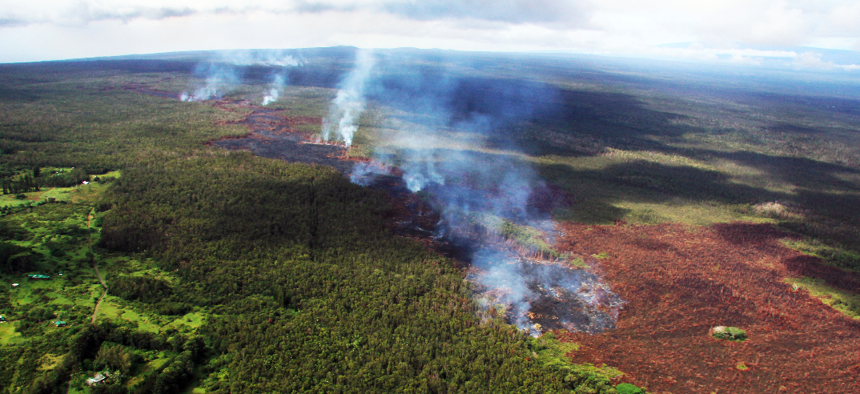
Slow-Moving Disaster Tests Officials on Hawaii’s Big Island

The lava flow that started June 27 is slowly approaching Pahoa, Hawaii. USGS

Connecting state and local government leaders
An advancing lava flow is threatening to cut off communities.
It’s an emergency situation that doesn’t fit the mold of a typical disaster and it’s unfolding on Hawaii’s Big Island, albeit very slowly.
A lava flow that started on June 27 inside Hawaii Volcanoes National Park has been gradually spreading toward the community of Pahoa and there are fears that it could cut off a state highway and isolate neighboring populated areas. Volcanologists have been mapping the lava’s likely path but it’s hard to predict exactly where and how quickly, or slowly, it will travel.
“Now if the lava decides to go south, than we're in really big, big trouble—we're in big trouble already, but we'll be in bigger trouble,” Warren Lee, Hawaii County’s Department of Public Works told HawaiiNewsNow on Wednesday.

Most county governments, whether they’re elsewhere in the Hawaiian islands or on the mainland, don’t have to deal with a slowly-moving oozing fiery threat. But officials in Hawaii County, which covers the entire Big Island, live with the constant threat from the Kilauea volcano, which has been in a regular state of eruption since 1983 and has slowly spewed lava out over a large section of the southeastern side of the island, destroying around 200 structures in the process.
The small seaside town of Kalapana was buried under 50 to 60 feet of lava nearly 25 years ago. This time, the lava is traveling in a different direction.
Civil defense officials have said that the June 27 lava flow, heading toward the northeast, doesn’t pose an immediate threat to homes or businesses and there are no current evacuation orders. But they’ve restricted access to the Kahoe Homesteads subdivisions to prevent tour groups who want to get a closer look at the lava flow from trespassing on private property.
But assuming that the lava continues its slow march into Pahoa, it will sever Highway 130 and pose a more direct threat to the community. That’s required local officials to be proactive to help mitigate the potential impacts of the lava and forecast the community’s future needs before the lava arrives.
The county government has been constructing emergency bypass roads that will give residents of the Lower Puna area access to the rest of the island should the current lava flow reach Highway 130.
But Hawaii County Mayor Billy Kenoi wants another emergency route, one that will go through the national park itself, expanded from one lane to two lanes. Officials at the national park have approved a one-lane evacuation route, HawaiiNewsNow reported, but a two-lane route would require additional environmental review.
In the meantime, with full attention on the lava flow, officials are trying to figure out what’s next.
“. . . [Y]ou cannot wait for something to happen to respond, you have to be prepared no matter what happens and there’s still a lot of unpredictability,” Kenoi told BJ Penn’s Hawaii News this week.
“There are homes that are already evacuating. These homes are empty and we need more presence of police, military … to make sure everybody’s safe,” Hawaii County Council member Greggor Ilagan said during a council meeting on Tuesday. “It might be early, but the danger is there.”


