The Alaska Town That Sank and (Mostly) Disappeared

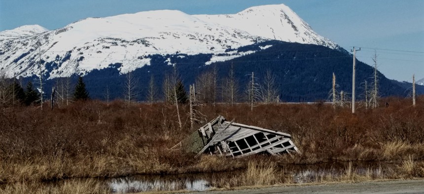
The ruins of Portage, Alaska, as seen from the Seward Highway. Michael Grass / Route Fifty
PHOTOS: The devastating Good Friday Earthquake nearly wiped this spot off the map in 1964. But not everything.
This is the fifth in a series of Route Fifty dispatches from Alaska.
PORTAGE, Alaska — Driving along the Seward Highway south from Anchorage, there’s a lot of stunningly beautiful scenery to look at going by out the window. Snowcapped mountains flank Turnagain Arm, a narrow waterway that separates most of the Kenai Peninsula from the North American continent. There are plenty of turnouts to stop and take photos.
At the far eastern end of that waterway, the Seward Highway makes a big U-turn curve crossing the vast mudflats where the Twentymile River, Placer River and Portage Creek meet saltwater.
Off in the distance, you can see the Whittier and Portage glaciers up in the mountains. But closer to the water level, you might be able to see the legacy of North America’s largest-recorded earthquake while zooming by at 55 mph.
This is where the settlement of Portage once stood. On March 27, 1964, the magnitude 9.2 Good Friday Earthquake struck south central Alaska, devastating the 49th State’s most populous region.
While Portage was never a large town, it was an important junction for transporting goods and services between Whittier, a port on an arm of Prince William Sound, and some of the local mining settlements that began to pop up in the 1890s.
But that important junction sat on soft soils that not only liquefied during the quake, but also sank about 8 to 10 feet in the process, which took less than five minutes.
According to this account of the earthquake’s impacts on Portage:
An eyewitness who was in a service station on the west side of the highway said he and a companion ran out the east door of the building as the concrete floor began to crack. They got about three feet out of the building when a crack about three feet wide opened between them. He said that cracks formed about each of them, leaving each man on a small island about three feet wide that moved up and down. He said it was like riding an open elevator. As he went down, the other man went up. And then they’d pass each other going in opposite directions. He said that the earth all around them broke into similar pieces and that as the blocks of frozen earth moved up and down, the cracks also opened and closed causing muddy water to spout as high as 50 feet. He said after the shaking stopped, water filled the open cracks.
Today, you can still see the remains of a few buildings going by on the Seward Highway. Additionally, there are also “ghost” forests—ashen-looking tree trunks that rise out of the marsh and mud. When the ground sank, the root systems were exposed to saltwater, killing the trees.

While Portage wasn’t totally erased by the quake, it was submerged at high tide and had to be abandoned. In the recovery from the quake, Alaska had to raise a portion of the Seward Highway, which sank into the mudflats along with Portage.
Fifty-three years after the Good Friday earthquake, this unusual corner of Alaska is a reminder about just how vulnerable certain places can be for human habitation, and how quickly they can vanish from view.

Michael Grass is Executive Editor of Government Executive’s Route Fifty and is based in Seattle.
NEXT STORY: Survey Spotlights Citizen Sentiments on Outsourcing


