What We Can Learn From Tuesday’s Orderly Tsunami Evacuations

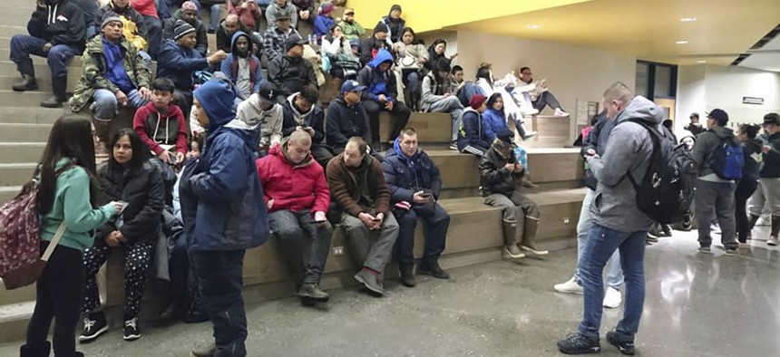
Evacuees gather at Kodiak High School in Kodiak, Alaska, Tuesday, Jan 23, 2018, after an earthquake and tsunami alert. Grigore Ciubotaru via AP
The 7.9 magnitude earthquake in the Gulf of Alaska didn’t cause major damage but the local response underscores some important lessons in emergency preparedness.
SEATTLE — While no significant tsunami developed following the magnitude 7.9 earthquake that rocked the Gulf of Alaska early Tuesday morning, residents in vulnerable coastal locations in southern Alaska, the Aleutian Islands and British Columbia evacuated to higher ground, just as many of them had practiced previously.
One of those spots of refuge was Kodiak High School, where the local borough school superintendent noted how calm and orderly the evacuation went.
Larry LeDoux of the Kodiak Island Borough School District said, according to the Anchorage Daily News:
”People are calm—very, very calm. At the high school it's pretty tight parking and people are letting people in and there's no sense of any kind of panic or anything. It's just something we've prepared for for years."
In Port Alberni, B.C., which sits at the end of a long narrow inlet on Vancouver Island and saw major tsunami damage following the March 1964 Great Alaskan earthquake, the town’s mayor woke up to turn on the city’s four tsunami sirens.
"The warning was repeated every 10 minutes for two minutes [in duration]. They're very loud, there's no way you can ignore them,” Mayor Mike Ruttan told the CBC. “And then in between time, the paper mill was blowing its horns for extended periods of time to let people know there was civic emergency."
That’s how good emergency preparedness is supposed to work, especially in places that face significant seismic risks like the Pacific coast.
Tsunamis, which are generated by large undersea earthquakes that usually strike along subduction zones, pose varying threats depending on the size and type of earthquake and the local coastal geography.
During the March 1964 quake in Alaska, which had a 9.2 magnitude, much of Crescent City, California, thousands of miles away, was inundated by the tsunami that followed, killing 11 people in that Northern California town.
Crescent City is particularly vulnerable to tsunamis due to its nearby undersea terrain, which amplifies the force and direction water into the low-lying city near the Oregon border. Tsunamis have hit Crescent City more than 30 times since the 1930s, Slate wrote in 2011 following the March 2011 Tohoku earthquake in Japan.
When the tsunami from that earthquake reached North America, it caused major damage in Crescent City’s harbor. This map developed by the California Emergency Management Agency, California Geological Survey and the University of Southern California, shows areas of Crescent City that are potentially at risk from a major tsunami.

Fortunately, distant tsunamis caused by earthquakes thousands of miles away offer a place like Crescent City hours of lead time to sound emergency sirens and initiate an evacuation. But tsunamis generated by local earthquakes offer far less time to seek a safer location.
The biggest worry for that type of West Coast disaster comes from the Cascadia Subduction Zone, where the next significant offshore megaquake—something perhaps as large as the 1964 quake in Alaska—is expected to cause catastrophic tsunami damage in low-lying coastal areas, especially in Oregon and Washington state. While that future earthquake, whenever it strikes, is expected to cause significant damage across the Pacific Northwest, emergency managers are particularly worried about the deadly tsunami disaster that will play out along the coast.
In such an earthquake scenario, communities built in vulnerable locations, like Seaside, Oregon and the Long Beach Peninsula in Washington, will have 15 to 30 minutes to seek higher ground before the coastal inundation starts. Thousands could be killed.
While many coastal communities have locations nearby that offer higher ground, others don’t.
As The Seattle Times reported in 2015, an analysis published in the Proceedings of the National Academy of Sciences shows how geography and topography will mean the difference between living and dying when the tsunami batters the shoreline and swamps coastal estuaries and inlets. Most people in Ocean Shores, Washington and Seaside, Oregon, according to the analysis will not have enough time to reach higher ground, even if they are running.
This map from Washington state's Department of Natural Resources shows the tsunami inundation zone in Ocean Shores, which includes the entire peninsula the community is built on.

For those unlucky locations, the study recommended constructing artificial high ground—refuges that can not only survive the earthquake but are built higher than the tsunami waves.
North America’s first such vertical evacuation shelter was built in Westport, Washington, where the roof of the gymnasium was designed to offer residents in the low-lying community a safe location to assemble while tsunami waves push inland.
RELATED on Route Fifty:
Michael Grass is Executive Editor of Government Executive’s Route Fifty and is based in Seattle.
NEXT STORY: The Leading Challenge Many U.S. Mayors Say Their Cities Are Facing


