Mapping the Post-Wildfire Landslide Risk in California’s Burn Zones

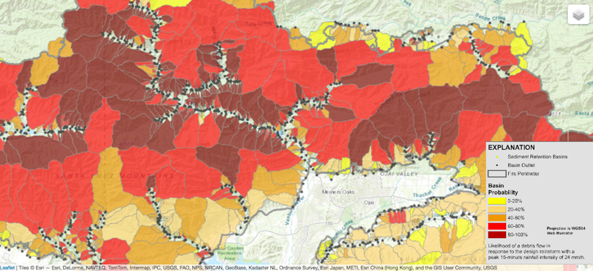
Burned areas from the Thomas Fire are likely to produce mudslides and debris flows. U.S. Geological Survey
With heavy rain predicted in some areas, this U.S. Geological Survey tool shows where the hazards of highest concern are located.
California’s rainy season last year may have replenished reservoirs in most parts of the state after a long, crippling drought, but the precipitation largely bypassed an area northwest of Los Angeles, in Santa Barbara and Ventura counties. Santa Barbara is now in its seventh year of drought and there are worries that similar conditions will return elsewhere in the Golden State.
Under these difficult circumstances, incoming rain—like the heavy precipitation that’s expected this week in parts of Southern California—would be welcomed as good news. But that’s not necessarily the case in the areas impacted by recent wildfires, including Thomas Fire in Santa Barbara and Ventura counties, where upwards of 4 inches of rains is predicted through Tuesday evening in some spots.
Rainfall can quickly turn that scorched landscape into mud and lead to landslides and flash flooding. Those conditions can not only bring more damage but can be deadly, too.
Hydrologists from the Ventura County Public Works Agency, which is part of the multi-jurisdictional team leading Thomas Fire recovery efforts, have warned residents in the Ojai Valley to expect twice the amount of water, debris and mud in local waterways as would normally be expected this time of year, according to the Ojai Valley News.
With the expected stormy weather in Southern California, residents in hillier terrain have been filling sandbags as local authorities have been erecting barriers to steer likely mudflows away from vulnerable spots.
A U.S. Geological Survey preliminary post-fire hazards assessment map illustrates the “likelihood of debris flow (in %), potential volume of debris flow (in m3), and combined relative debris flow hazard,” according to the USGS. “Predictions are made at the scale of the drainage basin, and at the scale of the individual stream segment.” The darker the red within the boundaries of a fire’s geographic footprint, the higher the risk.

And there’s a lot of red in the area burned by the Thomas Fire, which started Dec. 4 near Santa Paula in Ventura County and quickly spread westward by powerful Santa Ana winds into parts of the city of Ventura, Santa Barbara County and the Los Padres National Forest.
While parts of Ojai Valley escaped the fire, many of the watercourses that drain the Thomas Fire’s burned, rugged terrain flow through areas that escaped the initial disaster. Similarly, some of the coastal areas that were spared by the fire could still be impacted by mudflows coming out of the burn zone toward the Pacific Ocean.

Recent blazes in parts of Los Angeles County may not have grown to the size of the record-setting Thomas Fire, the USGS hazards map shows that the risk of mudslides and debris flows in areas burned by the La Tuña Fire in September is still very real and close to urbanized areas on the eastern flank of the heavily populated San Fernando Valley.

In Northern California, here’s what the post-fire landslide risk looks like in parts of Napa and Sonoma County, including areas impacted by the ferocious and deadly Tubbs Fire in October.
Michael Grass is Executive Editor of Government Executive’s Route Fifty and is based in Seattle.
NEXT STORY: The Fight for Medicaid Expansion Still Isn’t Over in Maine


