2 Maps That Better Explain the Landslide Risk From This Giant Crack Above an Interstate

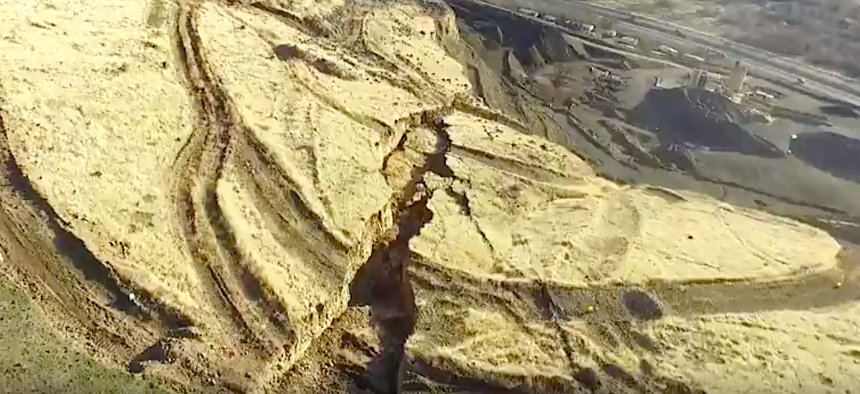
Drone footage shows the Rattlesnake Hills crack near Yakima, Washington. Washington State Department of Natural Resources
The waiting game continues at the Rattlesnake Hills where the ground recently “changed its behavior.”
SEATTLE — Monitoring the giant crack atop a ridge hundreds of feet above an interstate highway in Washington state has already proven to be a waiting game. As the fissure in the Rattlesnake Hills about 3 miles south of Yakima grows and the earth moves approximately 1.6 feet per week, geologists and engineers are not entirely clear what will happen next.
In the past week, the slow-moving landslide, which involves approximately 4 million cubic yards and 20 acres of land, “changed its behavior and it is now not possible to estimate when or even if a large failure event will occur,” according to Washington State Department of Natural Resources information about the ongoing ground movement in the Rattlesnake Hills.
The crack, shown above in drone footage from Jan. 22, was originally detected in October. A few weeks ago, with new concerns about the growing fissure, a local road hugging the base of the Rattlesnake Hills was shut down as the Washington State Department of Transportation positioned a chain of large steel containers weighed down by concrete barricades to help prevent any rockfall from reaching Interstate 82.
If there are signs of an impending ground failure, the Washington State Department of Transportation will close I-82 and re-route traffic as a precaution. As the Yakima Herald-Republic reported Wednesday, there are 55 state, local, federal and Yakima tribal agencies monitoring the landslide and preparing to respond to various scenarios.
Early on, there were fears that the ground movement could lead to a possible larger landslide , massive enough to block the interstate and, potentially, the Yakima River. The landslide involves blocks of basalt moving atop a weaker sedimentary layer.
And while it’s impossible to know right now what the earth is going to do, authorities in Washington state believe “the most probable scenario” is the Rattlesnake Hills landslide will be mostly contained within an adjacent quarry to the south of the area of current movement. Any landslide that moves beyond the quarry, including some adjacent homes, I-82 and the river are “low-probability scenarios.”
These two maps from the Washington State Department of Natural Resources better explain the topography, the risks and where the ground is moving.


In the meantime, the waiting game near Yakima continues.
Michael Grass is Executive Editor of Government Executive’s Route Fifty and is based in Seattle.
NEXT STORY: Local law enforcement agencies sign on to FirstNet


