Teaching automated vehicles the rules of the road


Connecting state and local government leaders
A new application will allow transportation departments to pass roadway infrastructure information to automated vehicles.
It probably goes without saying, but autonomous and highly automated vehicles need to understand the rules of the road if they’re going to merge smoothly onto the nation’s roadways.
Some of the information HAVs need for safe navigation are provided third parties that make high-definition maps using Google Street View or by walking city streets. HAVs also leverage their own sensors and machine learning to see and understand the signs on the road. But the local transportation departments haven’t had much of a say in what information such vehicles are getting.
“The challenge is those rules don’t exist in a digital format right now,” said Avery Ash, the head of autonomous mobility for Inrix, a cloud-solutions provider that specializes in connected car services and transportation analytics.
Some cities might have some digital information, like a spreadsheet of stop sign locations, but much of the required data is still on paper or in scanned PDFs, he explained. That makes it impossible to pass roadway infrastructure information to HAVs.
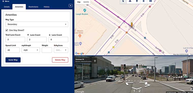
AV Road Rules, a new application from Inrix, is trying to change that. The application features a database where cities can digitize, validate and manage the traffic rules and restrictions for areas where HAVs will be operating.
AV Road Rules will allow local officials to go into a cloud-based portal and set the rules for intersections and stretches or roadway throughout their city. They’ll be able to set the location for stop signs, crosswalks, yield signs, one way streets, school zones and other rules the cars will need to be able to follow.

The rules can then be can be accessed by select HAVs via an application programming interface over either Wi-Fi or cellular networks.
Information won’t be flowing in just one direction, though. Sensors on the HAVs will be able to pick up issues with signage, line painting or potholes, acting like a roving 311 service-requesting system.
If an HAV comes to an intersection where it expects a stop sign, but its sensors aren’t picking anything up, it will send a notification to the AV Road Rules platform, according to Jason JonMichael. JonMichael is the assistant director for Smart Mobility in Austin, Texas, where Inrix is running a pilot of the platform.
“Then that information comes to me, and we go out and look at it, or maybe we don't have to and we can just look at our database and we either verify or correct whatever that is,” JonMichael said.
Part of the pilot will be deciding what information streaming off of HAVs is vital for local transportation departments because it won’t be necessary -- or possible -- to provide all of it. These cars have multiple sensors that are constantly observing the world around them and picking up around five to 10 terabytes of data an hour, Ash said.
“You would potentially bankrupt a city or a company like Inrix by trying to host that data or trying to figure out what to do with it,” he said.
HAVs are already trained to recognize specific categories of information -- like pavement quality or road signs -- so it will be a matter of determining what data the cities can use.
How often the information is transmitted from the platform to the cities is another consideration that will be worked out in the pilot, according to Ash. “Do you want a summary a couple times a day? Or do you want real-time information?” he said.
For cities, a centralized platform where HAV companies can access data will be a timesaver for local traffic departments, JonMichael said.
“It gets me out of having to serve up this type of file to every AV company that wants to come and deploy in Austin,” he said. “So eventually, from a scalability standpoint, you need something like this in order to properly partner with the private-sector AV companies to ensure they’re getting the same level of information across the board.”
The initial set of pilot users includes cities and road authorities in Austin, Texas; Boston, Mass.; Cambridge, Mass.; Portland, Maine; Regional Transportation Commission of Southern Nevada, which includes Las Vegas; Transport for West Midlands and Transport Scotland in the U.K. Automakers and operators slated to use the platform at launch include: Jaguar Land Rover, May Mobility, nuTonomy (an Aptiv company) and operators running Renovo’s Aware platform.

NEXT STORY: Surge In Older Homeless Residents Confounds Los Angeles Officials


