This Dangerous Volcano Is Dangerously Undermonitored

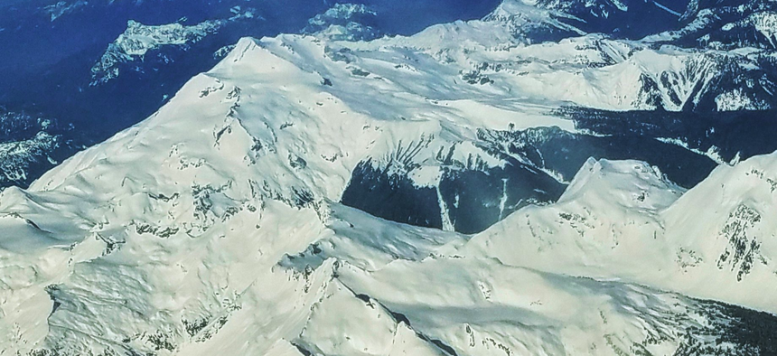
The Glacier Peak volcano, 65 miles northeast of Seattle can be difficult to spot from the both the populated Puget Sound lowlands and also flying over the Cascade Range. Michael Grass
And the battery on Glacier Peak's lone seismometer is expected to fail soon.
This past weekend, The Herald in Everett, Washington asked an important question: “Will seismometers be in place before our volcano erupts?”
“Our volcano” is Glacier Peak in the rugged mountainous wilderness of Snohomish County, about 50 miles due east of Everett and 65 miles northeast of Seattle. Compared to some of the other volcanic peaks in the Cascade Range, like Mount Rainier or Mount Saint Helens, the greater public is less aware of Glacier Peak in part because it’s hard to see from lowland population centers.
Nestled among other snow-capped mountains, it can even be difficult to pick out Glacier Peak, with an elevation of 10,568 feet, from among its neighbors when flying over the Cascades heading into Seattle.
Despite its low profile and relative remoteness, emergency managers and scientists say the public shouldn’t overlook the dangers from Glacier Peak. It has an explosive volcanic record and is considered a high-risk volcano by the U.S. Geological Survey.
Shortly after glaciers retreated at the end of the most recent ice age, about 13,000 years ago, Glacier Peak generated a sequence of six explosive eruptions. Two of the eruptions were Plinian and one ejected more than five times as much tephra as the May 18, 1980 eruption of Mount St. Helens.
Unlike the ongoing lava flow at the Kilauea on Hawaii’s Big Island, which has oozed across the landscape, Plinian eruptions are far more explosive, like the infamous event at Mount Vesuvius in 79 A.D that buried Pompeii in ash.
The next time Glacier Peak erupts in a big way, superheated volcanic mudflows called lahars are expected to quickly barrel down from the mountain and follow the course of the Skagit and Stillaguamish river valleys toward Puget Sound. That not only puts a handful of smaller mountain communities, like Darrington, is harm’s way, but also more populated areas in the lowlands, like Sedro-Woolley, Arlington and Mount Vernon, about 60 miles north of Seattle.

Volcanologists, emergency managers and local officials say more seismometers are needed on Glacier Peak to properly monitor the mountain and subtle movements that may signal an impending eruption. As the Herald reported, the lone seismometer on Glacier Peak, installed in 2001, will fail in the near future if its battery isn’t replaced.
The U.S. Geological Service wants to install four new seismic monitoring stations and change the battery of the existing unit. But because of Glacier Peak’s remote location, the USGS can’t simply drive up to the mountain, do its work and go. It also needs permission from the U.S. Forest Service, which administers the massive wilderness that surrounds the volcano—a 20-year permit for the new seismic monitoring stations is currently being considered.
In July, the Darrington town council approved a measure supporting the seismometer installation plan for Glacier Peak, according to the Herald.
Wilderness Watch, a Missoula, Montana-based environmental group, has opposed the seismic monitoring plan on Glacier Peak, saying that installation work, which would require the use of helicopters, would be disruptive and violates the federal Wilderness Act, which was passed in 1964.
According to Wilderness Watch, the Forest Service has “failed to justify how these [seismic] stations are necessary to protect the Wilderness and has failed to look at alternatives, including sites outside the Wilderness.”
But for scientists who monitor volcanoes and their hazards, they can’t adequately understand seismic movements under Glacier Peak unless there’s at least five sensors deployed on the mountain.
The lack of monitoring on some volcanoes is not a problem isolated to Glacier Peak.
“Several of our volcanoes in Washington state, and California, Oregon, Alaska, they have either no seismic monitors on them at all, or they have one,” Dave Norman, a geologist with Washington state’s Department of Natural Resources, told Route Fifty in January after a congressional hearing on funding for mitigating risks from natural disasters. “That means when you start to have some sort of rumbling below the volcano, if you don’t have a monitor on it, you really can’t tell what kind of a signal it’s sending you.”
Kayla Iacovino, a post-doctoral research fellow at Arizona State University who studies volcanoes and magma chambers, was among the scientists to call out Wilderness Watch’s opposition to seismic monitoring at Glacier Peak.
Iacovino tweeted on Monday: “It is nearly impossible to predict volcanic eruptions. By far, the most reliable way is seismic monitoring. InSAR (laser mapping) satellite passes are infrequent and not always diagnostic. Seismic data maps the deeper subsurface, where magma resides and mobilizes pre-eruption.”
It’s that pre-eruption mobilization that will help save lives the next time Glacier Peak stirs from its slumber. In the meantime, it’s simply a waiting game.
PREVIOUSLY on Route Fifty:
Michael Grass is Executive Editor of Government Executive’s Route Fifty and is based in Seattle.
NEXT STORY: Baaaad Commute: Goats Are the New York City Subway’s Latest Struggle


