After Floods, Some Cities Take On More Restrictive Zoning and Building Regulations

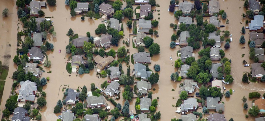
Flooding left much of Colorado underwater in 2013. Fort Collins was largely spared, in part because of their building regulations inspired by a 1997 flood. John Wark/AP Photo
Cities that have experienced flooding in recent years are trying new strategies to ensure that existing and new developments are prepared for the floods to come.
Floods are the most common natural disaster in the United States and with climate change the risk of rising waters makes both inland and coastal communities vulnerable. As floodplains expand by as much as 45% within the next 80 years, local governments are increasingly adopting forward-thinking regulations, instead of just creating emergency response plans.
New research from the Pew Charitable Trusts identified local policy solutions that cities are adopting in places where flooding has become a constant factor in residents’ lives.
In some localities, city leaders are changing building regulations and zoning ordinances with the hope that by shifting development away from vulnerable areas and shoring up the defenses of existing assets located in high-risk flood zones, they won’t have as many people stranded when flood waters arrive.
Fort Collins officials knew they had to change after a 1997 storm dumped 14.5 inches of rain on the Colorado city in 30 hours and flooded the nearby Spring Creek. The damage was catastrophic. Damage to homes and businesses totaled more than $250 million, and five people died. “The community saw the impacts this event had … loss of life, property damage, community disruption,” said Marsha Hilmes-Robinson, the city’s floodplain administrator.
In response, the city in 2000 banned new residential construction in the nearby Poudre River’s 100-year floodplain—meaning the area with a 1% chance of being flooded in a given year. “Even though the 1997 flood was not on the Poudre River, the initial focus for regulatory changes was on the Poudre because it is our largest floodplain,” Hilmes-Robinson explained.

The city also required that new nonresidential structures in the 100-year floodplain be elevated by two feet. Even before the flood, the city had banned the construction of critical facilities like hospitals and fire stations in the 100- and 500-year floodplains.
With the higher standards on construction, the city also made efforts to ease the burden on residents and developers with a Willing Buyer-Willing Seller program. If a residential or commercial property owner in a flood-prone area is having difficulty selling their property, the city may buy it from them.
Fort Collins’ work has already seen dividends. In 2013, Colorado was hit with its costliest natural disaster on record, when historic flooding caused nearly $4 billion in damage across 24 counties. While more than 1,800 homes and 200 businesses were destroyed, Fort Collins was largely spared. Nearly 14,000 structures had been built in the city since the flooding in 1997, but only eight of the buildings were damaged.
In Norfolk, Virginia, a city with more than 200 miles of shoreline, officials have acted to combat rising sea levels and heavy precipitation more recently. In 2018, the city passed new zoning ordinances that apply to new construction and redevelopment projects. Developers are now required to meet standards for flood-risk reduction, energy resilience, and stormwater management. If their plans don’t meet a point-based threshold, called the Resilience Quotient, they have to go through a much longer site review.
The city also updated its requirements to account for future sea level rises. Properties in the 100-year floodplain must now be elevated by three feet, basements are prohibited, and there are new limits on the amount of paved surfaces that can’t absorb rainwater. In the 500-year floodplain, new construction has to be elevated by three feet off the ground, or 1.5 feet above the floodplain, whichever is higher.
Lori Crouch, Norfolk’s director of communications, said that the government chose to focus on zoning for “a myriad of reasons,” including the fact that it accounts for both sea level rise and floods from stormwater system failures, like accidental blockages and short intense summer rains. “Zoning controls the physical development that occurs going forward so it is prudent to make new development and substantial redevelopment more resilient than current development,” she said. “Elevation is the simplest and most cost-effective way of reducing risk from flooding.”
Other cities, like Brevard, North Carolina, are also adopting stricter approaches. Located in a portion of the state that regularly gets heavy rainfall and is vulnerable to tropical storms, the city now requires developers to obtain a No Adverse Impact certification for new construction in flood plains. To secure the certificate, engineers examine development plans to ensure they won’t make flood risks worse for nearby property owners. New development can be bad for neighbors because additional pavement prevents rainwater from being absorbed into the ground, instead allowing it to run off and accumulate.
In an interview with Pew, Daniel Cobb, Brevard’s planning director, said the regulations are decreasing the number of people and properties at risk of flooding. “Our higher standards ... are protecting the life and property of our residents and neighbors both upstream and down,” he said.
Emma Coleman is the assistant editor for Route Fifty.
NEXT STORY: The Tumultuous Life of an Independent Redistricting Commissioner


